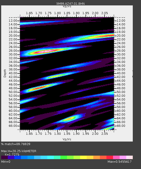
AZ47 Arizona47 - Earthquake Result Viewer

Earthquake location: Southeast Of Honshu, Japan
Earthquake latitude/longitude: 33.9/139.4
Earthquake time(UTC): 2000/07/30 (212) 12:25:45 GMT
Earthquake Depth: 10 km
Earthquake Magnitude: 6.0 MB, 6.5 MS, 6.5 MW, 6.5 MW
Earthquake Catalog/Contributor: WHDF/NEIC
Network: XM Rio Grande Seismic Transect
Station: AZ47 Arizona47
Lat/Lon: 36.64 N/109.33 W
Elevation: 1752 m
Distance: 85.0 deg
Az: 48.791 deg
Baz: 308.93 deg
Ray Param: 0.045070235
Estimated Moho Depth: 28.25 km
Estimated Crust Vp/Vs: 1.73
Assumed Crust Vp: 6.476 km/s
Estimated Crust Vs: 3.749 km/s
Estimated Crust Poisson's Ratio: 0.25
Radial Match: 89.76929 %
Radial Bump: 400
Transverse Match: 76.95728 %
Transverse Bump: 400
SOD ConfigId: 3744
Insert Time: 2010-02-26 17:19:15.603 +0000
GWidth: 2.5
Max Bumps: 400
Tol: 0.001

Signal To Noise

ChannelStoNSTALTA
XM:AZ47:01:BHN:20000730T12:37:49.658013Z1.05208678.774246E-88.3398504E-8
XM:AZ47:01:BHE:20000730T12:37:49.658013Z1.12247348.601783E-87.6632396E-8
XM:AZ47:01:BHZ:20000730T12:37:49.658013Z6.25854874.4054957E-77.039164E-8
Arrivals
Ps3.3 SECOND
PpPs12 SECOND
PsPs/PpSs15 SECOND