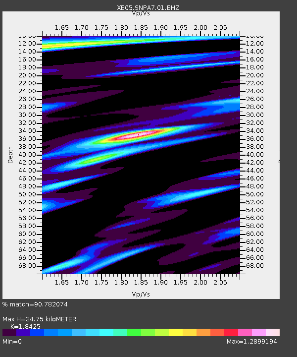
SNPA7 SNPA7 - Earthquake Result Viewer

Earthquake location: Solomon Islands
Earthquake latitude/longitude: -6.8/155.5
Earthquake time(UTC): 2006/09/01 (244) 10:18:51 GMT
Earthquake Depth: 38 km
Earthquake Magnitude: 6.3 MB, 6.7 MS, 6.8 MW, 6.7 MW
Earthquake Catalog/Contributor: WHDF/NEIC
Network: XE Sierra Nevada EarthScope Project- EarthScope Flex Array
Station: SNPA7 SNPA7
Lat/Lon: 39.01 N/119.89 W
Elevation: 2350 m
Distance: 90.0 deg
Az: 50.864 deg
Baz: 261.387 deg
Ray Param: 0.041698024
Estimated Moho Depth: 34.75 km
Estimated Crust Vp/Vs: 1.84
Assumed Crust Vp: 6.279 km/s
Estimated Crust Vs: 3.408 km/s
Estimated Crust Poisson's Ratio: 0.29
Radial Match: 90.782074 %
Radial Bump: 400
Transverse Match: 82.926094 %
Transverse Bump: 400
SOD ConfigId: 268666
Insert Time: 2010-03-09 17:52:06.216 +0000
GWidth: 2.5
Max Bumps: 400
Tol: 0.001

Signal To Noise

ChannelStoNSTALTA
XE:SNPA7:01:BHZ:20060901T10:31:15.975Z12.8519921.5599633E-61.213791E-7
XE:SNPA7:01:BHN:20060901T10:31:15.975Z1.49743511.8195033E-71.21508E-7
XE:SNPA7:01:BHE:20060901T10:31:15.975Z6.55484965.242283E-77.997564E-8
Arrivals
Ps4.8 SECOND
PpPs15 SECOND
PsPs/PpSs20 SECOND