You are here: Home > Network List > AV - Alaska Volcano Observatory Stations List
> Station SPCR Ckakachatna River, Mount Spurr, Alaska > Earthquake Result Viewer
SPCR Ckakachatna River, Mount Spurr, Alaska - Earthquake Result Viewer
| Earthquake location: |
Taiwan |
| Earthquake latitude/longitude: |
23.4/121.6 |
| Earthquake time(UTC): |
2022/03/22 (081) 17:41:38 GMT |
| Earthquake Depth: |
24 km |
| Earthquake Magnitude: |
6.7 mww |
| Earthquake Catalog/Contributor: |
NEIC PDE/us |
|
| Network: |
AV Alaska Volcano Observatory |
| Station: |
SPCR Ckakachatna River, Mount Spurr, Alaska |
| Lat/Lon: |
61.20 N/152.21 W |
| Elevation: |
984 m |
|
| Distance: |
68.0 deg |
| Az: |
31.414 deg |
| Baz: |
278.589 deg |
| Ray Param: |
0.0565768 |
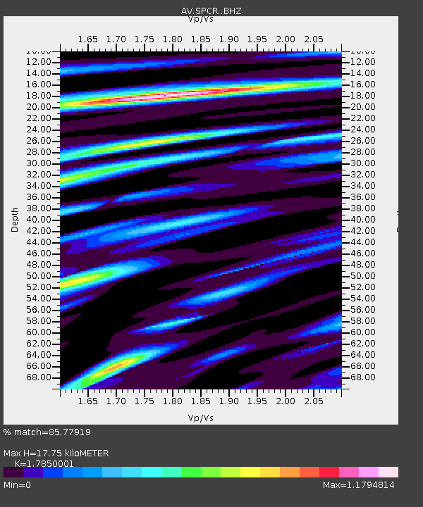
| Estimated Moho Depth: |
17.75 km |
| Estimated Crust Vp/Vs: |
1.79 |
| Assumed Crust Vp: |
6.566 km/s |
| Estimated Crust Vs: |
3.679 km/s |
| Estimated Crust Poisson's Ratio: |
0.27 |
|
| Radial Match: |
85.77919 % |
| Radial Bump: |
400 |
| Transverse Match: |
82.88129 % |
| Transverse Bump: |
400 |
| SOD ConfigId: |
27527651 |
| Insert Time: |
2022-04-05 17:51:27.554 +0000 |
| GWidth: |
2.5 |
| Max Bumps: |
400 |
| Tol: |
0.001 |
|
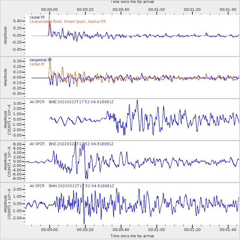
Signal To Noise
| Channel | StoN | STA | LTA |
| AV:SPCR: :BHZ:20220322T17:52:04.818981Z | 5.67556 | 1.9816994E-6 | 3.4916368E-7 |
| AV:SPCR: :BHN:20220322T17:52:04.818981Z | 1.0835931 | 3.5507273E-7 | 3.2768088E-7 |
| AV:SPCR: :BHE:20220322T17:52:04.818981Z | 1.9861957 | 7.90565E-7 | 3.9802975E-7 |
| Arrivals |
| Ps | 2.2 SECOND |
| PpPs | 7.2 SECOND |
| PsPs/PpSs | 9.4 SECOND |


