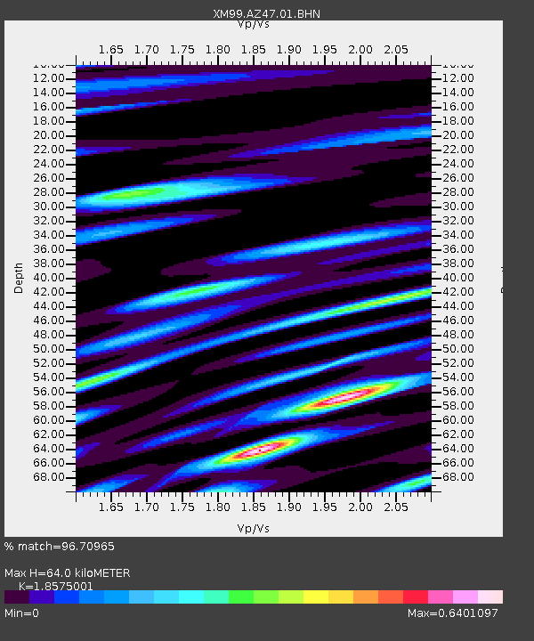
AZ47 Arizona47 - Earthquake Result Viewer
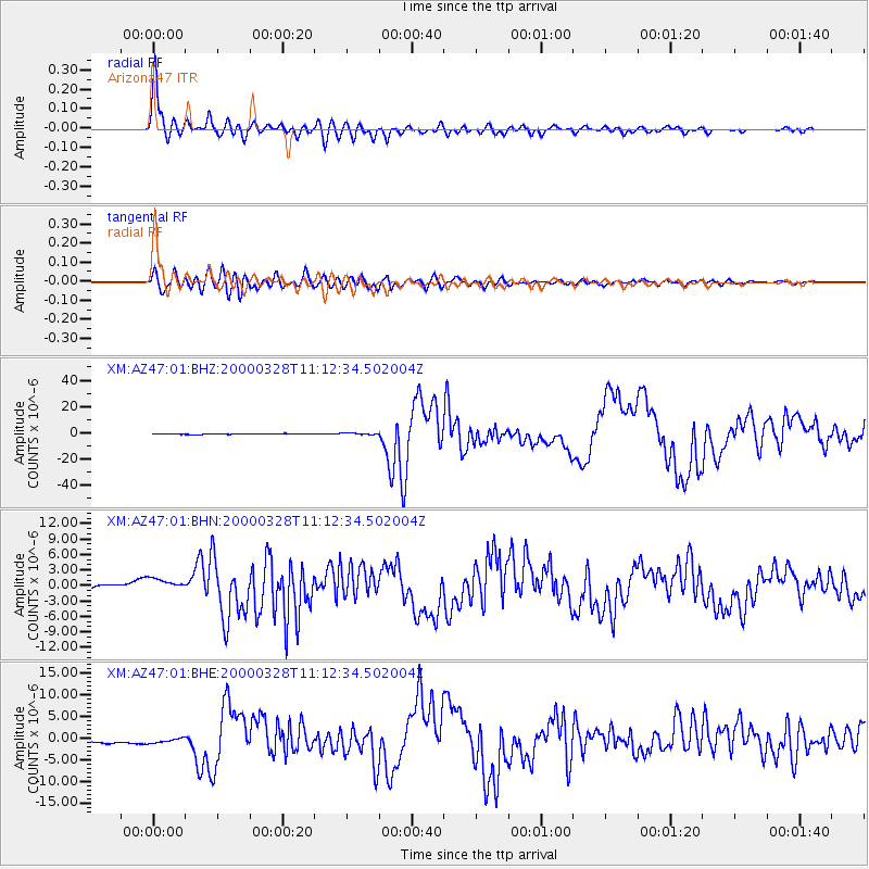
Earthquake location: Volcano Islands, Japan Region
Earthquake latitude/longitude: 22.3/143.7
Earthquake time(UTC): 2000/03/28 (088) 11:00:22 GMT
Earthquake Depth: 126 km
Earthquake Magnitude: 6.8 MB, 7.6 MS, 7.6 MW, 7.6 MW
Earthquake Catalog/Contributor: WHDF/NEIC
Network: XM Rio Grande Seismic Transect
Station: AZ47 Arizona47
Lat/Lon: 36.64 N/109.33 W
Elevation: 1752 m
Distance: 89.6 deg
Az: 50.308 deg
Baz: 297.66 deg
Ray Param: 0.04170974
Estimated Moho Depth: 64.0 km
Estimated Crust Vp/Vs: 1.86
Assumed Crust Vp: 6.476 km/s
Estimated Crust Vs: 3.486 km/s
Estimated Crust Poisson's Ratio: 0.30
Radial Match: 96.70965 %
Radial Bump: 372
Transverse Match: 91.17943 %
Transverse Bump: 400
SOD ConfigId: 27569
Insert Time: 2010-02-26 17:19:18.537 +0000
GWidth: 2.5
Max Bumps: 400
Tol: 0.001

Signal To Noise

ChannelStoNSTALTA
XM:AZ47:01:BHN:20000328T11:12:34.502004Z2.40014581.4328749E-65.9699494E-7
XM:AZ47:01:BHE:20000328T11:12:34.502004Z1.23242077.274626E-75.9027127E-7
XM:AZ47:01:BHZ:20000328T11:12:34.502004Z2.16247925.3964436E-72.4954892E-7
Arrivals
Ps8.6 SECOND
PpPs28 SECOND
PsPs/PpSs36 SECOND