You are here: Home > Network List > XM99 - Rio Grande Seismic Transect Stations List
> Station AZ47 Arizona47 > Earthquake Result Viewer
AZ47 Arizona47 - Earthquake Result Viewer
| Earthquake location: |
Windward Islands |
| Earthquake latitude/longitude: |
11.1/-62.6 |
| Earthquake time(UTC): |
2000/10/04 (278) 14:37:44 GMT |
| Earthquake Depth: |
110 km |
| Earthquake Magnitude: |
5.6 MB, 5.4 MS, 6.1 MW, 5.9 MD |
| Earthquake Catalog/Contributor: |
WHDF/NEIC |
|
| Network: |
XM Rio Grande Seismic Transect |
| Station: |
AZ47 Arizona47 |
| Lat/Lon: |
36.64 N/109.33 W |
| Elevation: |
1752 m |
|
| Distance: |
49.1 deg |
| Az: |
309.172 deg |
| Baz: |
108.924 deg |
| Ray Param: |
0.06854585 |
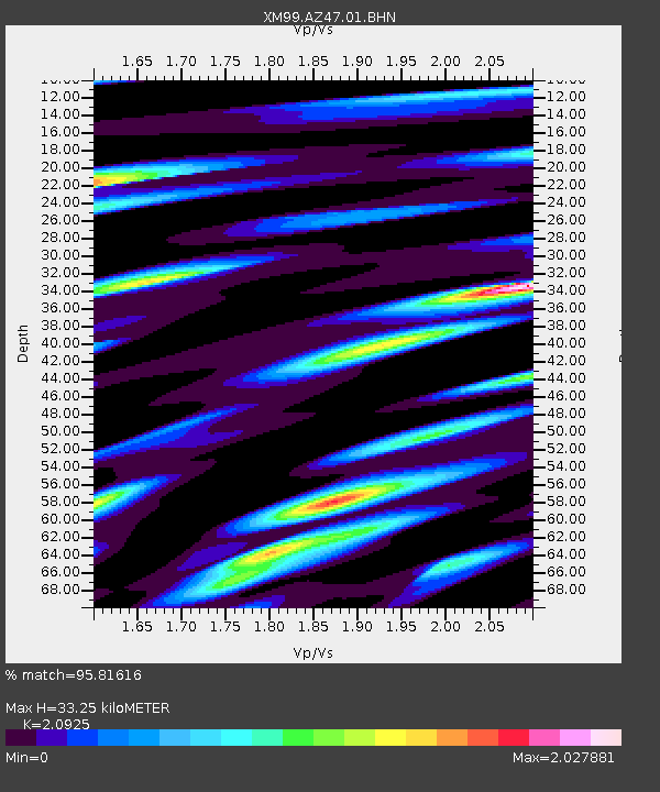
| Estimated Moho Depth: |
33.25 km |
| Estimated Crust Vp/Vs: |
2.09 |
| Assumed Crust Vp: |
6.476 km/s |
| Estimated Crust Vs: |
3.095 km/s |
| Estimated Crust Poisson's Ratio: |
0.35 |
|
| Radial Match: |
95.81616 % |
| Radial Bump: |
400 |
| Transverse Match: |
86.31556 % |
| Transverse Bump: |
400 |
| SOD ConfigId: |
16820 |
| Insert Time: |
2010-02-26 17:19:26.053 +0000 |
| GWidth: |
2.5 |
| Max Bumps: |
400 |
| Tol: |
0.001 |
|

Signal To Noise
| Channel | StoN | STA | LTA |
| XM:AZ47:01:BHN:20001004T14:45:49.979987Z | 2.1488063 | 2.9752354E-7 | 1.3845991E-7 |
| XM:AZ47:01:BHE:20001004T14:45:49.979987Z | 4.8892446 | 5.408358E-7 | 1.1061746E-7 |
| XM:AZ47:01:BHZ:20001004T14:45:49.979987Z | 8.412451 | 5.9424985E-7 | 7.0639324E-8 |
| Arrivals |
| Ps | 5.9 SECOND |
| PpPs | 15 SECOND |
| PsPs/PpSs | 21 SECOND |


