You are here: Home > Network List > AV - Alaska Volcano Observatory Stations List
> Station MAPS Pakushin Southeast, Makushin Volcano, Alaska > Earthquake Result Viewer
MAPS Pakushin Southeast, Makushin Volcano, Alaska - Earthquake Result Viewer
| Earthquake location: |
Taiwan |
| Earthquake latitude/longitude: |
23.5/121.6 |
| Earthquake time(UTC): |
2022/03/22 (081) 19:35:02 GMT |
| Earthquake Depth: |
10 km |
| Earthquake Magnitude: |
5.7 mb |
| Earthquake Catalog/Contributor: |
NEIC PDE/us |
|
| Network: |
AV Alaska Volcano Observatory |
| Station: |
MAPS Pakushin Southeast, Makushin Volcano, Alaska |
| Lat/Lon: |
53.81 N/166.94 W |
| Elevation: |
333 m |
|
| Distance: |
60.5 deg |
| Az: |
40.241 deg |
| Baz: |
270.0 deg |
| Ray Param: |
0.061502326 |
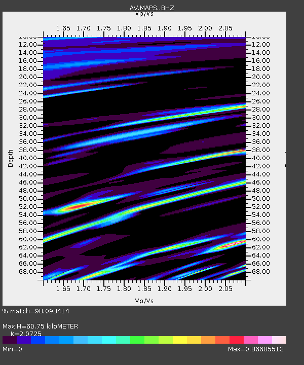
| Estimated Moho Depth: |
60.75 km |
| Estimated Crust Vp/Vs: |
2.07 |
| Assumed Crust Vp: |
3.943 km/s |
| Estimated Crust Vs: |
1.903 km/s |
| Estimated Crust Poisson's Ratio: |
0.35 |
|
| Radial Match: |
98.093414 % |
| Radial Bump: |
151 |
| Transverse Match: |
98.01775 % |
| Transverse Bump: |
137 |
| SOD ConfigId: |
27527651 |
| Insert Time: |
2022-04-05 19:41:11.956 +0000 |
| GWidth: |
2.5 |
| Max Bumps: |
400 |
| Tol: |
0.001 |
|
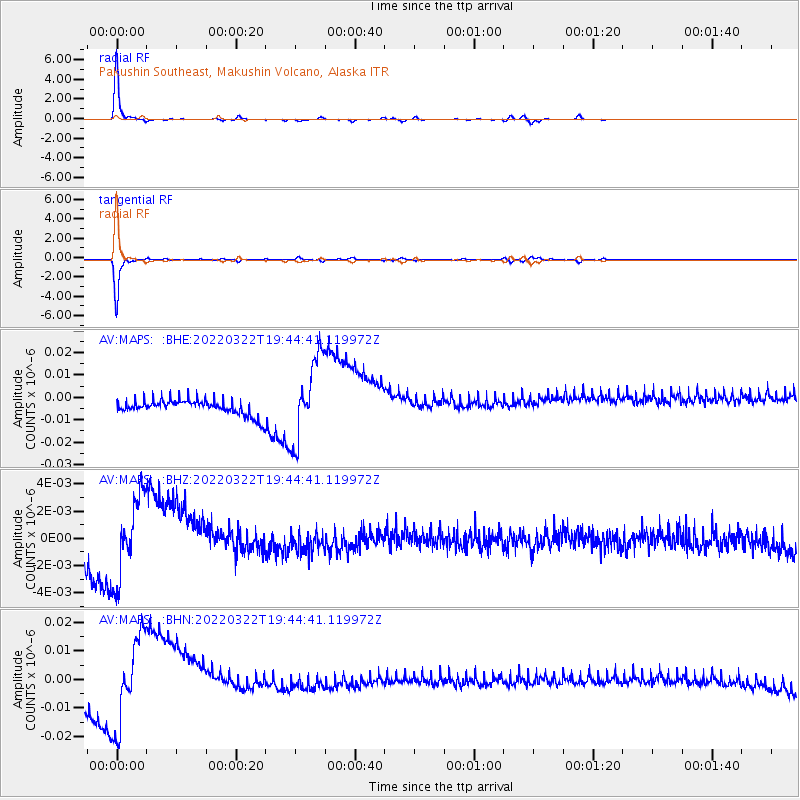
Signal To Noise
| Channel | StoN | STA | LTA |
| AV:MAPS: :BHZ:20220322T19:44:41.119972Z | 4.219076 | 3.108248E-9 | 7.3671297E-10 |
| AV:MAPS: :BHN:20220322T19:44:41.119972Z | 5.137798 | 1.5550771E-8 | 3.0267384E-9 |
| AV:MAPS: :BHE:20220322T19:44:41.119972Z | 5.455451 | 1.8334564E-8 | 3.3607788E-9 |
| Arrivals |
| Ps | 17 SECOND |
| PpPs | 47 SECOND |
| PsPs/PpSs | 63 SECOND |


