You are here: Home > Network List > XM99 - Rio Grande Seismic Transect Stations List
> Station AZ47 Arizona47 > Earthquake Result Viewer
AZ47 Arizona47 - Earthquake Result Viewer
| Earthquake location: |
Vanuatu Islands |
| Earthquake latitude/longitude: |
-14.9/167.2 |
| Earthquake time(UTC): |
2001/01/09 (009) 16:49:28 GMT |
| Earthquake Depth: |
103 km |
| Earthquake Magnitude: |
6.3 MB, 6.6 MS, 7.6 ME, 7.0 MW |
| Earthquake Catalog/Contributor: |
WHDF/NEIC |
|
| Network: |
XM Rio Grande Seismic Transect |
| Station: |
AZ47 Arizona47 |
| Lat/Lon: |
36.64 N/109.33 W |
| Elevation: |
1752 m |
|
| Distance: |
93.7 deg |
| Az: |
53.209 deg |
| Baz: |
254.245 deg |
| Ray Param: |
0.04115633 |
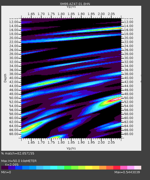
| Estimated Moho Depth: |
50.0 km |
| Estimated Crust Vp/Vs: |
2.09 |
| Assumed Crust Vp: |
6.476 km/s |
| Estimated Crust Vs: |
3.106 km/s |
| Estimated Crust Poisson's Ratio: |
0.35 |
|
| Radial Match: |
82.857155 % |
| Radial Bump: |
400 |
| Transverse Match: |
69.94439 % |
| Transverse Bump: |
400 |
| SOD ConfigId: |
16820 |
| Insert Time: |
2010-02-26 17:19:29.693 +0000 |
| GWidth: |
2.5 |
| Max Bumps: |
400 |
| Tol: |
0.001 |
|

Signal To Noise
| Channel | StoN | STA | LTA |
| XM:AZ47:01:BHN:20010109T17:02:01.632019Z | 1.7654423 | 3.1061376E-7 | 1.7594105E-7 |
| XM:AZ47:01:BHE:20010109T17:02:01.632019Z | 0.9336517 | 2.2111513E-7 | 2.3682828E-7 |
| XM:AZ47:01:BHZ:20010109T17:02:01.632019Z | 3.789501 | 1.0705526E-6 | 2.8250489E-7 |
| Arrivals |
| Ps | 8.5 SECOND |
| PpPs | 23 SECOND |
| PsPs/PpSs | 32 SECOND |


