You are here: Home > Network List > UU - University of Utah Regional Network Stations List
> Station KNB Kanab, UT, USA > Earthquake Result Viewer
KNB Kanab, UT, USA - Earthquake Result Viewer
| Earthquake location: |
Near East Coast Of Kamchatka |
| Earthquake latitude/longitude: |
51.6/157.9 |
| Earthquake time(UTC): |
2018/07/06 (187) 01:40:08 GMT |
| Earthquake Depth: |
80 km |
| Earthquake Magnitude: |
6.1 Mwp |
| Earthquake Catalog/Contributor: |
NEIC PDE/us |
|
| Network: |
UU University of Utah Regional Network |
| Station: |
KNB Kanab, UT, USA |
| Lat/Lon: |
37.02 N/112.82 W |
| Elevation: |
1715 m |
|
| Distance: |
61.7 deg |
| Az: |
65.401 deg |
| Baz: |
314.901 deg |
| Ray Param: |
0.060522057 |
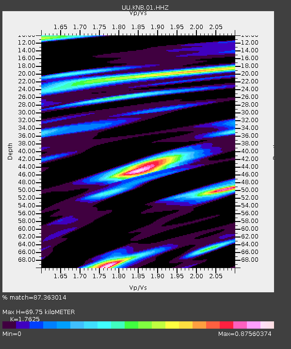
| Estimated Moho Depth: |
69.75 km |
| Estimated Crust Vp/Vs: |
1.76 |
| Assumed Crust Vp: |
6.194 km/s |
| Estimated Crust Vs: |
3.514 km/s |
| Estimated Crust Poisson's Ratio: |
0.26 |
|
| Radial Match: |
87.363014 % |
| Radial Bump: |
395 |
| Transverse Match: |
82.352234 % |
| Transverse Bump: |
378 |
| SOD ConfigId: |
2752131 |
| Insert Time: |
2018-07-20 01:57:45.582 +0000 |
| GWidth: |
2.5 |
| Max Bumps: |
400 |
| Tol: |
0.001 |
|

Signal To Noise
| Channel | StoN | STA | LTA |
| UU:KNB:01:HHZ:20180706T01:49:47.30499Z | 27.21462 | 1.0167871E-7 | 3.7361794E-9 |
| UU:KNB:01:HHN:20180706T01:49:47.30499Z | 18.081795 | 4.2993793E-8 | 2.3777393E-9 |
| UU:KNB:01:HHE:20180706T01:49:47.30499Z | 5.786469 | 2.6935858E-8 | 4.654973E-9 |
| Arrivals |
| Ps | 9.0 SECOND |
| PpPs | 30 SECOND |
| PsPs/PpSs | 39 SECOND |


