You are here: Home > Network List > XM99 - Rio Grande Seismic Transect Stations List
> Station AZ47 Arizona47 > Earthquake Result Viewer
AZ47 Arizona47 - Earthquake Result Viewer
| Earthquake location: |
Northern Chile |
| Earthquake latitude/longitude: |
-18.9/-69.2 |
| Earthquake time(UTC): |
1999/11/30 (334) 04:01:53 GMT |
| Earthquake Depth: |
128 km |
| Earthquake Magnitude: |
6.2 MB, 6.6 MW, 6.5 MW |
| Earthquake Catalog/Contributor: |
WHDF/NEIC |
|
| Network: |
XM Rio Grande Seismic Transect |
| Station: |
AZ47 Arizona47 |
| Lat/Lon: |
36.64 N/109.33 W |
| Elevation: |
1752 m |
|
| Distance: |
67.0 deg |
| Az: |
325.698 deg |
| Baz: |
138.447 deg |
| Ray Param: |
0.05689368 |
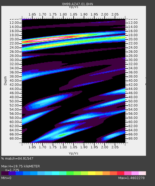
| Estimated Moho Depth: |
19.75 km |
| Estimated Crust Vp/Vs: |
1.73 |
| Assumed Crust Vp: |
6.476 km/s |
| Estimated Crust Vs: |
3.754 km/s |
| Estimated Crust Poisson's Ratio: |
0.25 |
|
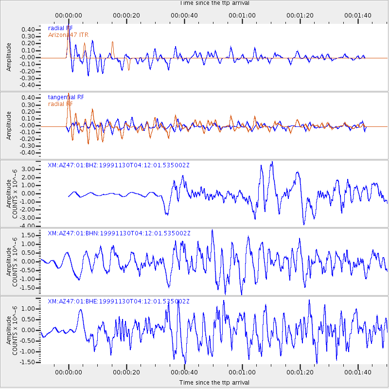
| Radial Match: |
84.91547 % |
| Radial Bump: |
400 |
| Transverse Match: |
57.397373 % |
| Transverse Bump: |
400 |
| SOD ConfigId: |
27569 |
| Insert Time: |
2010-02-26 17:19:30.786 +0000 |
| GWidth: |
2.5 |
| Max Bumps: |
400 |
| Tol: |
0.001 |
|
Signal To Noise
| Channel | StoN | STA | LTA |
| XM:AZ47:01:BHN:19991130T04:12:01.535002Z | 2.902821 | 6.1664673E-7 | 2.1243017E-7 |
| XM:AZ47:01:BHE:19991130T04:12:01.535002Z | 2.583835 | 4.683765E-7 | 1.8127184E-7 |
| XM:AZ47:01:BHZ:19991130T04:12:01.535002Z | 7.7577343 | 1.2507184E-6 | 1.6122212E-7 |
| Arrivals |
| Ps | 2.3 SECOND |
| PpPs | 8.0 SECOND |
| PsPs/PpSs | 10 SECOND |


