You are here: Home > Network List > UU - University of Utah Regional Network Stations List
> Station LIUT Lila Canyon, UT, USA > Earthquake Result Viewer
LIUT Lila Canyon, UT, USA - Earthquake Result Viewer
| Earthquake location: |
Near East Coast Of Kamchatka |
| Earthquake latitude/longitude: |
51.6/157.9 |
| Earthquake time(UTC): |
2018/07/06 (187) 01:40:08 GMT |
| Earthquake Depth: |
80 km |
| Earthquake Magnitude: |
6.1 Mwp |
| Earthquake Catalog/Contributor: |
NEIC PDE/us |
|
| Network: |
UU University of Utah Regional Network |
| Station: |
LIUT Lila Canyon, UT, USA |
| Lat/Lon: |
39.42 N/110.33 W |
| Elevation: |
2178 m |
|
| Distance: |
61.4 deg |
| Az: |
61.885 deg |
| Baz: |
314.763 deg |
| Ray Param: |
0.06071159 |
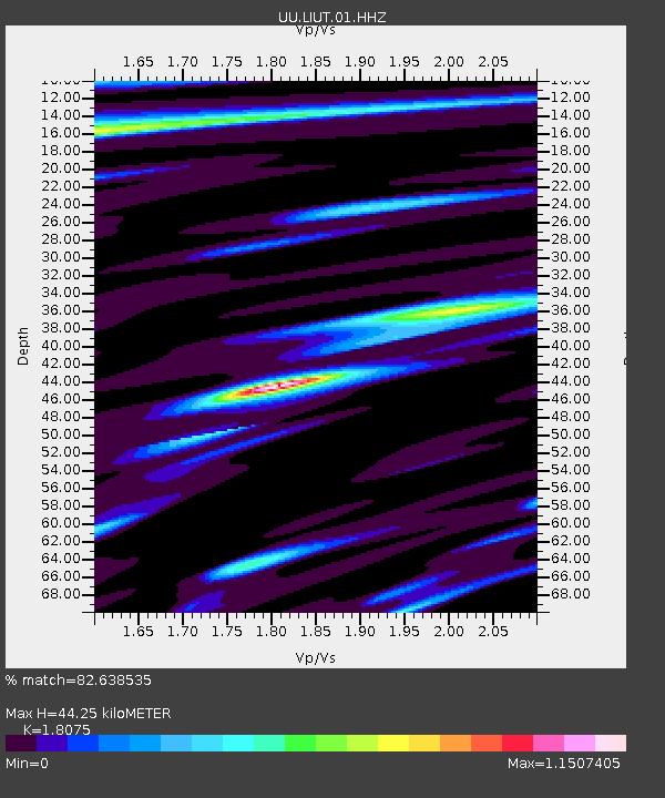
| Estimated Moho Depth: |
44.25 km |
| Estimated Crust Vp/Vs: |
1.81 |
| Assumed Crust Vp: |
6.207 km/s |
| Estimated Crust Vs: |
3.434 km/s |
| Estimated Crust Poisson's Ratio: |
0.28 |
|
| Radial Match: |
82.638535 % |
| Radial Bump: |
400 |
| Transverse Match: |
77.467834 % |
| Transverse Bump: |
400 |
| SOD ConfigId: |
2752131 |
| Insert Time: |
2018-07-20 01:57:49.601 +0000 |
| GWidth: |
2.5 |
| Max Bumps: |
400 |
| Tol: |
0.001 |
|

Signal To Noise
| Channel | StoN | STA | LTA |
| UU:LIUT:01:HHZ:20180706T01:49:45.289976Z | 24.172812 | 9.765825E-8 | 4.040004E-9 |
| UU:LIUT:01:HHN:20180706T01:49:45.289976Z | 4.8802114 | 2.1165421E-8 | 4.3369885E-9 |
| UU:LIUT:01:HHE:20180706T01:49:45.289976Z | 11.687145 | 3.0036322E-8 | 2.5700306E-9 |
| Arrivals |
| Ps | 6.0 SECOND |
| PpPs | 19 SECOND |
| PsPs/PpSs | 25 SECOND |


