You are here: Home > Network List > CI - Caltech Regional Seismic Network Stations List
> Station MPP McPhearson Peak > Earthquake Result Viewer
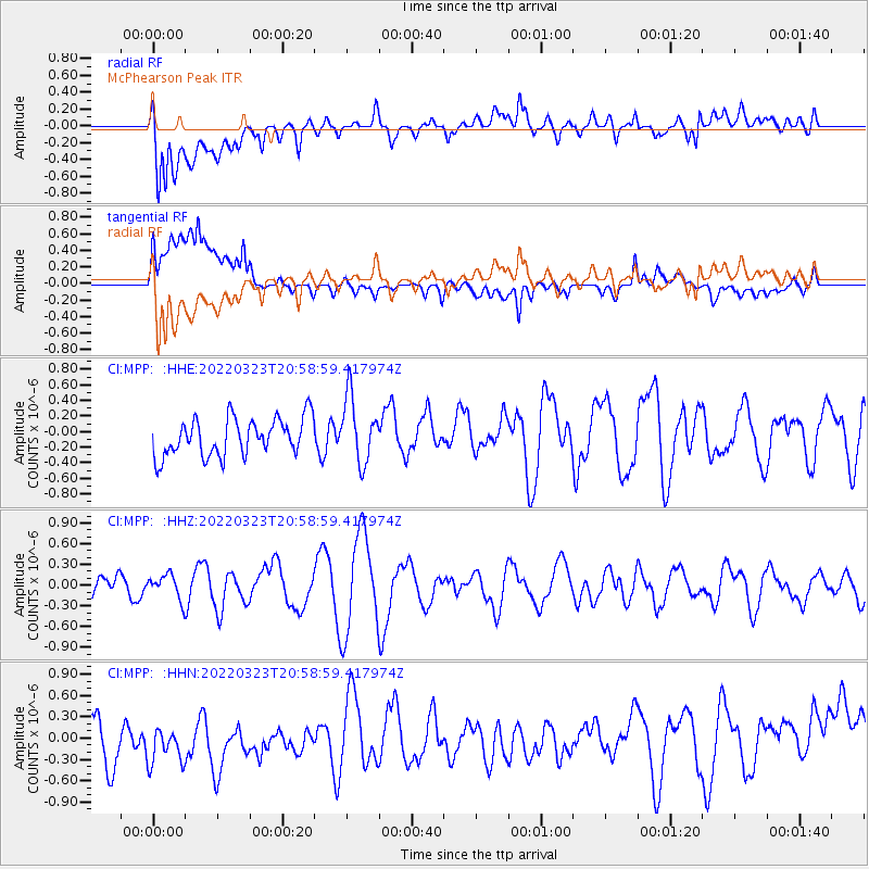
MPP McPhearson Peak - Earthquake Result Viewer
*The percent match for this event was below the threshold and hence no stack was calculated.
| Earthquake location: |
Tonga Islands Region |
| Earthquake latitude/longitude: |
-23.5/-175.1 |
| Earthquake time(UTC): |
2022/03/23 (082) 20:47:31 GMT |
| Earthquake Depth: |
10 km |
| Earthquake Magnitude: |
5.5 Mww |
| Earthquake Catalog/Contributor: |
NEIC PDE/us |
|
| Network: |
CI Caltech Regional Seismic Network |
| Station: |
MPP McPhearson Peak |
| Lat/Lon: |
34.89 N/119.81 W |
| Elevation: |
1739 m |
|
| Distance: |
78.2 deg |
| Az: |
43.661 deg |
| Baz: |
230.453 deg |
| Ray Param: |
$rayparam |
*The percent match for this event was below the threshold and hence was not used in the summary stack. |
|
| Radial Match: |
55.460976 % |
| Radial Bump: |
400 |
| Transverse Match: |
37.88113 % |
| Transverse Bump: |
400 |
| SOD ConfigId: |
27527651 |
| Insert Time: |
2022-04-06 20:57:25.230 +0000 |
| GWidth: |
2.5 |
| Max Bumps: |
400 |
| Tol: |
0.001 |
|
Signal To Noise
| Channel | StoN | STA | LTA |
| CI:MPP: :HHZ:20220323T20:58:59.417974Z | 0.8467544 | 1.7971807E-7 | 2.1224345E-7 |
| CI:MPP: :HHN:20220323T20:58:59.417974Z | 1.0330055 | 7.349076E-7 | 7.1142665E-7 |
| CI:MPP: :HHE:20220323T20:58:59.417974Z | 1.7605047 | 4.220162E-7 | 2.397132E-7 |
| Arrivals |
| Ps | |
| PpPs | |
| PsPs/PpSs | |


