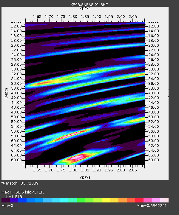
SNPA8 SNPA8 - Earthquake Result Viewer

Earthquake location: Kuril Islands
Earthquake latitude/longitude: 46.3/153.3
Earthquake time(UTC): 2006/10/13 (286) 13:47:39 GMT
Earthquake Depth: 8.0 km
Earthquake Magnitude: 5.5 MB, 5.8 MS, 6.3 MW, 5.8 MW
Earthquake Catalog/Contributor: WHDF/NEIC
Network: XE Sierra Nevada EarthScope Project- EarthScope Flex Array
Station: SNPA8 SNPA8
Lat/Lon: 39.10 N/119.60 W
Elevation: 2004 m
Distance: 61.4 deg
Az: 62.321 deg
Baz: 307.844 deg
Ray Param: 0.060931124
Estimated Moho Depth: 66.5 km
Estimated Crust Vp/Vs: 1.82
Assumed Crust Vp: 6.279 km/s
Estimated Crust Vs: 3.459 km/s
Estimated Crust Poisson's Ratio: 0.28
Radial Match: 83.72389 %
Radial Bump: 400
Transverse Match: 68.3685 %
Transverse Bump: 400
SOD ConfigId: 268666
Insert Time: 2010-03-09 17:55:50.222 +0000
GWidth: 2.5
Max Bumps: 400
Tol: 0.001

Signal To Noise

ChannelStoNSTALTA
XE:SNPA8:01:BHZ:20061013T13:57:24.973008Z5.26997474.2166715E-78.001312E-8
XE:SNPA8:01:BHN:20061013T13:57:24.973008Z0.777978241.00944725E-71.2975264E-7
XE:SNPA8:01:BHE:20061013T13:57:24.973008Z1.85198922.6068537E-71.4075967E-7
Arrivals
Ps9.0 SECOND
PpPs29 SECOND
PsPs/PpSs38 SECOND