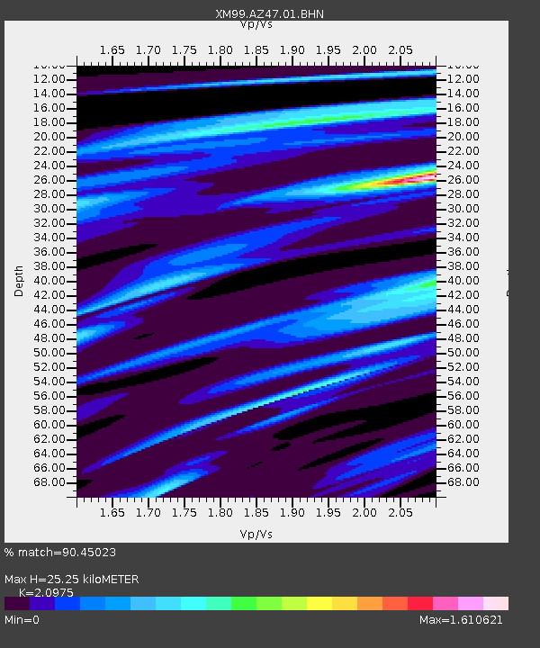
AZ47 Arizona47 - Earthquake Result Viewer

Earthquake location: Costa Rica
Earthquake latitude/longitude: 9.0/-84.2
Earthquake time(UTC): 1999/08/20 (232) 10:02:21 GMT
Earthquake Depth: 20 km
Earthquake Magnitude: 6.1 MB, 6.9 MS, 7.0 MW, 6.1 ML
Earthquake Catalog/Contributor: WHDF/NEIC
Network: XM Rio Grande Seismic Transect
Station: AZ47 Arizona47
Lat/Lon: 36.64 N/109.33 W
Elevation: 1752 m
Distance: 35.7 deg
Az: 324.13 deg
Baz: 133.984 deg
Ray Param: 0.077043496
Estimated Moho Depth: 25.25 km
Estimated Crust Vp/Vs: 2.10
Assumed Crust Vp: 6.476 km/s
Estimated Crust Vs: 3.087 km/s
Estimated Crust Poisson's Ratio: 0.35
Radial Match: 90.45023 %
Radial Bump: 400
Transverse Match: 65.35061 %
Transverse Bump: 400
SOD ConfigId: 27569
Insert Time: 2010-02-26 17:19:35.597 +0000
GWidth: 2.5
Max Bumps: 400
Tol: 0.001

Signal To Noise

ChannelStoNSTALTA
XM:AZ47:01:BHN:19990820T10:08:47.636987Z3.0830889.216086E-72.9892388E-7
XM:AZ47:01:BHE:19990820T10:08:47.636987Z7.4545951.2800643E-61.717148E-7
XM:AZ47:01:BHZ:19990820T10:08:47.636987Z45.531311.4498264E-63.1842404E-8
Arrivals
Ps4.6 SECOND
PpPs11 SECOND
PsPs/PpSs16 SECOND