You are here: Home > Network List > IU - Global Seismograph Network (GSN - IRIS/USGS) Stations List
> Station PMG Port Moresby, New Guinea > Earthquake Result Viewer
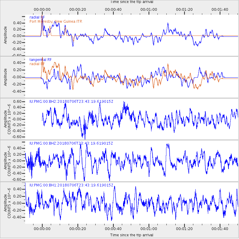
PMG Port Moresby, New Guinea - Earthquake Result Viewer
*The percent match for this event was below the threshold and hence no stack was calculated.
| Earthquake location: |
Western Indian-Antarctic Ridge |
| Earthquake latitude/longitude: |
-49.7/125.6 |
| Earthquake time(UTC): |
2018/07/06 (187) 23:35:43 GMT |
| Earthquake Depth: |
10 km |
| Earthquake Magnitude: |
5.5 Mww |
| Earthquake Catalog/Contributor: |
NEIC PDE/us |
|
| Network: |
IU Global Seismograph Network (GSN - IRIS/USGS) |
| Station: |
PMG Port Moresby, New Guinea |
| Lat/Lon: |
9.40 S/147.16 E |
| Elevation: |
90 m |
|
| Distance: |
43.9 deg |
| Az: |
31.451 deg |
| Baz: |
200.101 deg |
| Ray Param: |
$rayparam |
*The percent match for this event was below the threshold and hence was not used in the summary stack. |
|
| Radial Match: |
53.871426 % |
| Radial Bump: |
400 |
| Transverse Match: |
50.662327 % |
| Transverse Bump: |
400 |
| SOD ConfigId: |
2752131 |
| Insert Time: |
2018-07-20 23:37:18.060 +0000 |
| GWidth: |
2.5 |
| Max Bumps: |
400 |
| Tol: |
0.001 |
|
Signal To Noise
| Channel | StoN | STA | LTA |
| IU:PMG:00:BHZ:20180706T23:43:19.619015Z | 0.7819007 | 1.2616178E-7 | 1.6135269E-7 |
| IU:PMG:00:BH1:20180706T23:43:19.619015Z | 0.71255237 | 2.3020553E-7 | 3.2307173E-7 |
| IU:PMG:00:BH2:20180706T23:43:19.619015Z | 0.9728746 | 2.2445128E-7 | 2.3070938E-7 |
| Arrivals |
| Ps | |
| PpPs | |
| PsPs/PpSs | |


