You are here: Home > Network List > XM99 - Rio Grande Seismic Transect Stations List
> Station AZ49 Arizona49 > Earthquake Result Viewer
AZ49 Arizona49 - Earthquake Result Viewer
| Earthquake location: |
Fiji Islands Region |
| Earthquake latitude/longitude: |
-16.8/174.3 |
| Earthquake time(UTC): |
2000/08/09 (222) 22:55:59 GMT |
| Earthquake Depth: |
33 km |
| Earthquake Magnitude: |
5.7 MB, 6.3 MS, 6.4 MW, 6.4 MW |
| Earthquake Catalog/Contributor: |
WHDF/NEIC |
|
| Network: |
XM Rio Grande Seismic Transect |
| Station: |
AZ49 Arizona49 |
| Lat/Lon: |
36.89 N/109.69 W |
| Elevation: |
1512 m |
|
| Distance: |
89.2 deg |
| Az: |
51.072 deg |
| Baz: |
248.344 deg |
| Ray Param: |
0.04200266 |
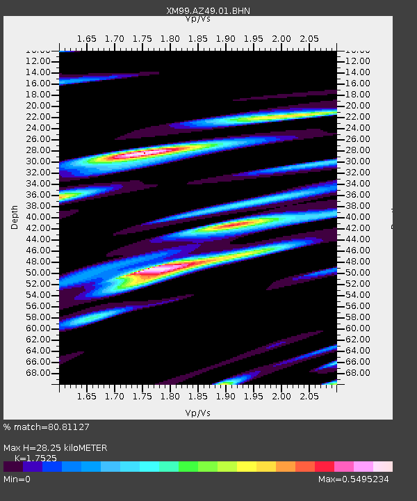
| Estimated Moho Depth: |
28.25 km |
| Estimated Crust Vp/Vs: |
1.75 |
| Assumed Crust Vp: |
6.476 km/s |
| Estimated Crust Vs: |
3.695 km/s |
| Estimated Crust Poisson's Ratio: |
0.26 |
|
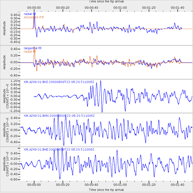
| Radial Match: |
80.81127 % |
| Radial Bump: |
400 |
| Transverse Match: |
59.65091 % |
| Transverse Bump: |
400 |
| SOD ConfigId: |
27569 |
| Insert Time: |
2010-02-26 17:19:47.591 +0000 |
| GWidth: |
2.5 |
| Max Bumps: |
400 |
| Tol: |
0.001 |
|
Signal To Noise
| Channel | StoN | STA | LTA |
| XM:AZ49:01:BHN:20000809T23:08:20.511006Z | 0.9298263 | 5.540044E-8 | 5.9581495E-8 |
| XM:AZ49:01:BHE:20000809T23:08:20.511006Z | 1.1716427 | 9.331228E-8 | 7.964227E-8 |
| XM:AZ49:01:BHZ:20000809T23:08:20.511006Z | 1.4430505 | 1.1946787E-7 | 8.2788425E-8 |
| Arrivals |
| Ps | 3.4 SECOND |
| PpPs | 12 SECOND |
| PsPs/PpSs | 15 SECOND |


