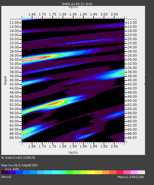
AZ49 Arizona49 - Earthquake Result Viewer
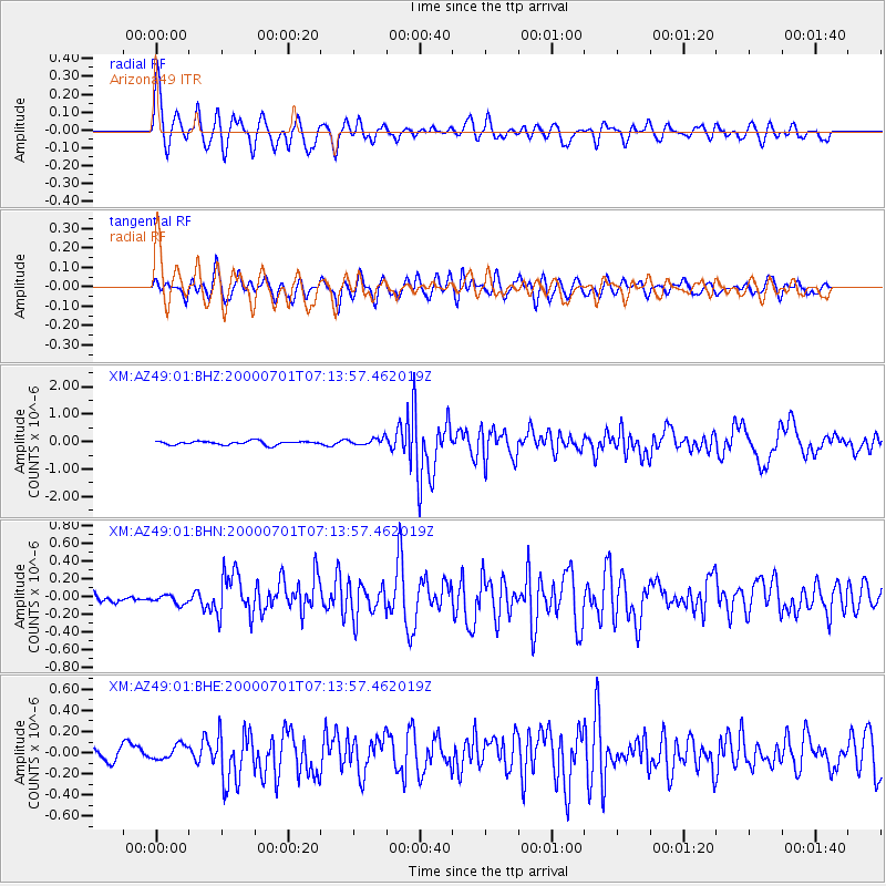
Earthquake location: Near S. Coast Of Honshu, Japan
Earthquake latitude/longitude: 34.2/139.1
Earthquake time(UTC): 2000/07/01 (183) 07:01:55 GMT
Earthquake Depth: 10 km
Earthquake Magnitude: 6.0 MB, 6.1 MS, 6.2 MW, 6.2 MW
Earthquake Catalog/Contributor: WHDF/NEIC
Network: XM Rio Grande Seismic Transect
Station: AZ49 Arizona49
Lat/Lon: 36.89 N/109.69 W
Elevation: 1512 m
Distance: 84.6 deg
Az: 48.674 deg
Baz: 309.091 deg
Ray Param: 0.045385707
Estimated Moho Depth: 29.5 km
Estimated Crust Vp/Vs: 1.64
Assumed Crust Vp: 6.476 km/s
Estimated Crust Vs: 3.937 km/s
Estimated Crust Poisson's Ratio: 0.21
Radial Match: 83.428535 %
Radial Bump: 400
Transverse Match: 75.629074 %
Transverse Bump: 400
SOD ConfigId: 3744
Insert Time: 2010-02-26 17:19:48.802 +0000
GWidth: 2.5
Max Bumps: 400
Tol: 0.001

Signal To Noise

ChannelStoNSTALTA
XM:AZ49:01:BHN:20000701T07:13:57.462019Z0.70100654.7305967E-86.748292E-8
XM:AZ49:01:BHE:20000701T07:13:57.462019Z1.09828626.7412046E-86.137931E-8
XM:AZ49:01:BHZ:20000701T07:13:57.462019Z1.91660191.2882464E-76.7215126E-8
Arrivals
Ps3.0 SECOND
PpPs12 SECOND
PsPs/PpSs15 SECOND