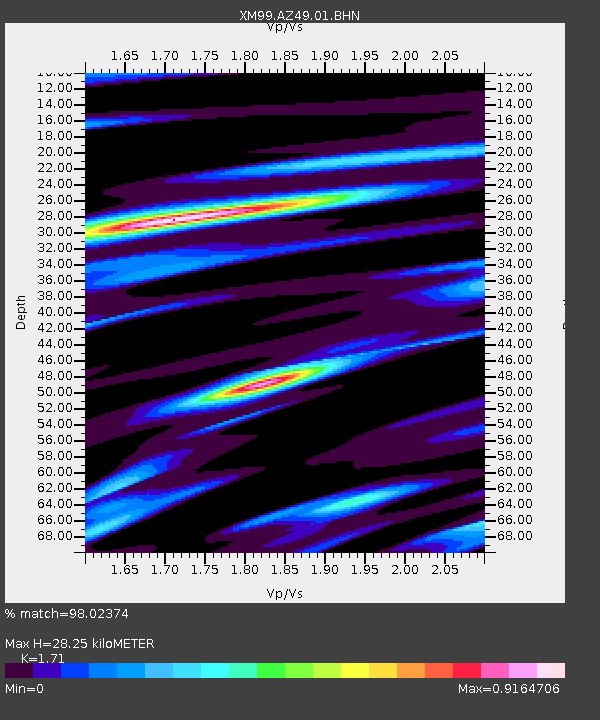
AZ49 Arizona49 - Earthquake Result Viewer
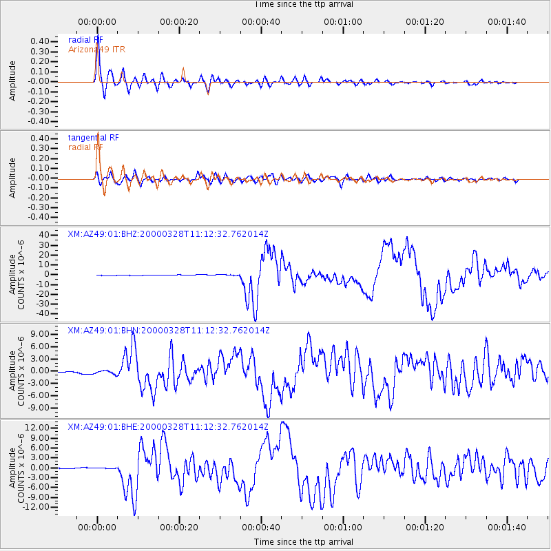
Earthquake location: Volcano Islands, Japan Region
Earthquake latitude/longitude: 22.3/143.7
Earthquake time(UTC): 2000/03/28 (088) 11:00:22 GMT
Earthquake Depth: 126 km
Earthquake Magnitude: 6.8 MB, 7.6 MS, 7.6 MW, 7.6 MW
Earthquake Catalog/Contributor: WHDF/NEIC
Network: XM Rio Grande Seismic Transect
Station: AZ49 Arizona49
Lat/Lon: 36.89 N/109.69 W
Elevation: 1512 m
Distance: 89.2 deg
Az: 50.219 deg
Baz: 297.446 deg
Ray Param: 0.041762754
Estimated Moho Depth: 28.25 km
Estimated Crust Vp/Vs: 1.71
Assumed Crust Vp: 6.476 km/s
Estimated Crust Vs: 3.787 km/s
Estimated Crust Poisson's Ratio: 0.24
Radial Match: 98.02374 %
Radial Bump: 400
Transverse Match: 87.94759 %
Transverse Bump: 400
SOD ConfigId: 27569
Insert Time: 2010-02-26 17:19:51.985 +0000
GWidth: 2.5
Max Bumps: 400
Tol: 0.001

Signal To Noise

ChannelStoNSTALTA
XM:AZ49:01:BHN:20000328T11:12:32.762014Z1.80438534.311614E-72.3895194E-7
XM:AZ49:01:BHE:20000328T11:12:32.762014Z1.08835692.085198E-71.915914E-7
XM:AZ49:01:BHZ:20000328T11:12:32.762014Z1.44942024.810454E-73.3188817E-7
Arrivals
Ps3.2 SECOND
PpPs12 SECOND
PsPs/PpSs15 SECOND