You are here: Home > Network List > TX - Texas Seismological Network Stations List
> Station MB09 Lenorah > Earthquake Result Viewer
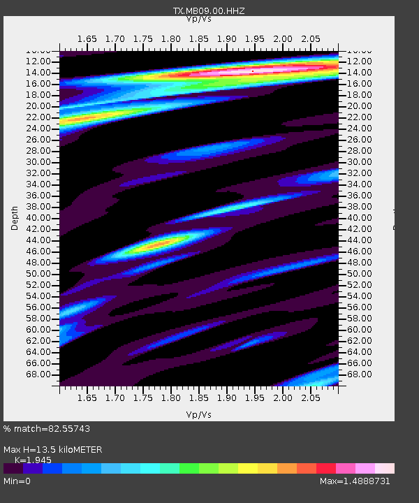
MB09 Lenorah - Earthquake Result Viewer
| Earthquake location: |
Near Coast Of Ecuador |
| Earthquake latitude/longitude: |
0.9/-79.6 |
| Earthquake time(UTC): |
2022/03/27 (086) 04:28:13 GMT |
| Earthquake Depth: |
27 km |
| Earthquake Magnitude: |
5.8 mww |
| Earthquake Catalog/Contributor: |
NEIC PDE/us |
|
| Network: |
TX Texas Seismological Network |
| Station: |
MB09 Lenorah |
| Lat/Lon: |
32.34 N/101.82 W |
| Elevation: |
798 m |
|
| Distance: |
37.6 deg |
| Az: |
328.369 deg |
| Baz: |
141.723 deg |
| Ray Param: |
0.07598353 |
| Estimated Moho Depth: |
13.5 km |
| Estimated Crust Vp/Vs: |
1.95 |
| Assumed Crust Vp: |
6.426 km/s |
| Estimated Crust Vs: |
3.304 km/s |
| Estimated Crust Poisson's Ratio: |
0.32 |
|
| Radial Match: |
82.55743 % |
| Radial Bump: |
350 |
| Transverse Match: |
58.970753 % |
| Transverse Bump: |
400 |
| SOD ConfigId: |
27527651 |
| Insert Time: |
2022-04-10 04:56:36.343 +0000 |
| GWidth: |
2.5 |
| Max Bumps: |
400 |
| Tol: |
0.001 |
|

Signal To Noise
| Channel | StoN | STA | LTA |
| TX:MB09:00:HHZ:20220327T04:34:55.320008Z | 3.5664787 | 5.296281E-7 | 1.4850168E-7 |
| TX:MB09:00:HHN:20220327T04:34:55.320008Z | 1.4551805 | 3.356011E-7 | 2.3062505E-7 |
| TX:MB09:00:HHE:20220327T04:34:55.320008Z | 2.248504 | 3.0762197E-7 | 1.3681185E-7 |
| Arrivals |
| Ps | 2.1 SECOND |
| PpPs | 5.8 SECOND |
| PsPs/PpSs | 7.9 SECOND |


