You are here: Home > Network List > US - United States National Seismic Network Stations List
> Station AMTX Amarillo, Texas, USA > Earthquake Result Viewer
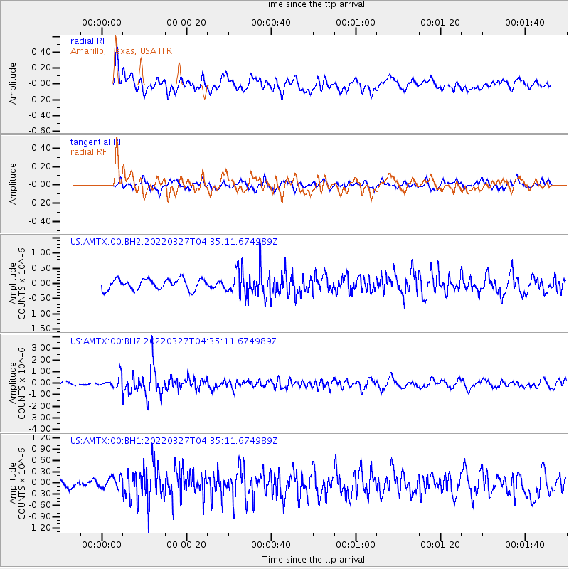
AMTX Amarillo, Texas, USA - Earthquake Result Viewer
*The percent match for this event was below the threshold and hence no stack was calculated.
| Earthquake location: |
Near Coast Of Ecuador |
| Earthquake latitude/longitude: |
0.9/-79.6 |
| Earthquake time(UTC): |
2022/03/27 (086) 04:28:13 GMT |
| Earthquake Depth: |
27 km |
| Earthquake Magnitude: |
5.8 mww |
| Earthquake Catalog/Contributor: |
NEIC PDE/us |
|
| Network: |
US United States National Seismic Network |
| Station: |
AMTX Amarillo, Texas, USA |
| Lat/Lon: |
34.53 N/101.41 W |
| Elevation: |
1010 m |
|
| Distance: |
39.2 deg |
| Az: |
330.935 deg |
| Baz: |
143.96 deg |
| Ray Param: |
$rayparam |
*The percent match for this event was below the threshold and hence was not used in the summary stack. |
|
| Radial Match: |
67.11618 % |
| Radial Bump: |
400 |
| Transverse Match: |
60.904903 % |
| Transverse Bump: |
400 |
| SOD ConfigId: |
27527651 |
| Insert Time: |
2022-04-10 04:57:27.031 +0000 |
| GWidth: |
2.5 |
| Max Bumps: |
400 |
| Tol: |
0.001 |
|
Signal To Noise
| Channel | StoN | STA | LTA |
| US:AMTX:00:BHZ:20220327T04:35:11.674989Z | 3.1069708 | 5.4616083E-7 | 1.7578564E-7 |
| US:AMTX:00:BH1:20220327T04:35:11.674989Z | 0.81905884 | 1.561611E-7 | 1.9065918E-7 |
| US:AMTX:00:BH2:20220327T04:35:11.674989Z | 0.75244796 | 1.3166523E-7 | 1.749825E-7 |
| Arrivals |
| Ps | |
| PpPs | |
| PsPs/PpSs | |


