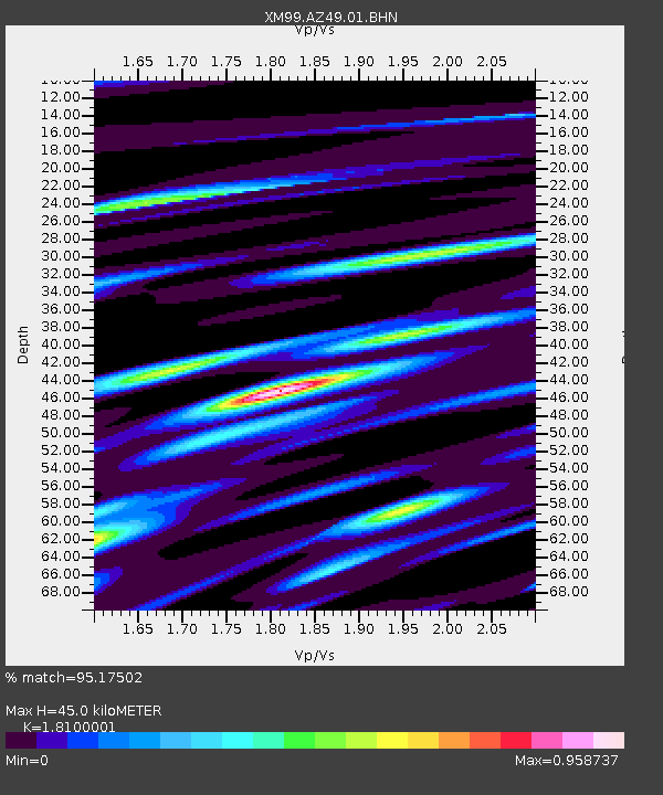
AZ49 Arizona49 - Earthquake Result Viewer

Earthquake location: Windward Islands
Earthquake latitude/longitude: 11.1/-62.6
Earthquake time(UTC): 2000/10/04 (278) 14:37:44 GMT
Earthquake Depth: 110 km
Earthquake Magnitude: 5.6 MB, 5.4 MS, 6.1 MW, 5.9 MD
Earthquake Catalog/Contributor: WHDF/NEIC
Network: XM Rio Grande Seismic Transect
Station: AZ49 Arizona49
Lat/Lon: 36.89 N/109.69 W
Elevation: 1512 m
Distance: 49.5 deg
Az: 309.362 deg
Baz: 108.834 deg
Ray Param: 0.06832298
Estimated Moho Depth: 45.0 km
Estimated Crust Vp/Vs: 1.81
Assumed Crust Vp: 6.476 km/s
Estimated Crust Vs: 3.578 km/s
Estimated Crust Poisson's Ratio: 0.28
Radial Match: 95.17502 %
Radial Bump: 400
Transverse Match: 85.08078 %
Transverse Bump: 400
SOD ConfigId: 16820
Insert Time: 2010-02-26 17:20:01.543 +0000
GWidth: 2.5
Max Bumps: 400
Tol: 0.001

Signal To Noise

ChannelStoNSTALTA
XM:AZ49:01:BHN:20001004T14:45:52.665991Z1.58245871.847538E-71.167511E-7
XM:AZ49:01:BHE:20001004T14:45:52.665991Z5.1188036.9110496E-71.3501301E-7
XM:AZ49:01:BHZ:20001004T14:45:52.665991Z6.26436851.1150044E-61.7799151E-7
Arrivals
Ps6.0 SECOND
PpPs18 SECOND
PsPs/PpSs24 SECOND