You are here: Home > Network List > XE05 - Sierra Nevada EarthScope Project- EarthScope Flex Array Stations List
> Station SNPB5 SNPB5 > Earthquake Result Viewer
SNPB5 SNPB5 - Earthquake Result Viewer
| Earthquake location: |
Peru-Brazil Border Region |
| Earthquake latitude/longitude: |
-7.9/-74.4 |
| Earthquake time(UTC): |
2007/07/12 (193) 05:23:49 GMT |
| Earthquake Depth: |
152 km |
| Earthquake Magnitude: |
5.9 MB, 6.1 MW, 6.0 MW |
| Earthquake Catalog/Contributor: |
WHDF/NEIC |
|
| Network: |
XE Sierra Nevada EarthScope Project- EarthScope Flex Array |
| Station: |
SNPB5 SNPB5 |
| Lat/Lon: |
38.83 N/120.55 W |
| Elevation: |
1404 m |
|
| Distance: |
63.2 deg |
| Az: |
320.881 deg |
| Baz: |
126.85 deg |
| Ray Param: |
0.059256498 |
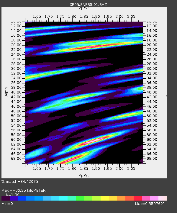
| Estimated Moho Depth: |
60.25 km |
| Estimated Crust Vp/Vs: |
1.89 |
| Assumed Crust Vp: |
6.597 km/s |
| Estimated Crust Vs: |
3.491 km/s |
| Estimated Crust Poisson's Ratio: |
0.31 |
|
| Radial Match: |
84.42075 % |
| Radial Bump: |
400 |
| Transverse Match: |
73.547226 % |
| Transverse Bump: |
400 |
| SOD ConfigId: |
268666 |
| Insert Time: |
2010-03-09 18:03:40.489 +0000 |
| GWidth: |
2.5 |
| Max Bumps: |
400 |
| Tol: |
0.001 |
|

Signal To Noise
| Channel | StoN | STA | LTA |
| XE:SNPB5:01:BHZ:20070712T05:33:30.840Z | 10.918655 | 5.713246E-7 | 5.232555E-8 |
| XE:SNPB5:01:BHN:20070712T05:33:30.840Z | 1.4292593 | 3.0665493E-7 | 2.1455513E-7 |
| XE:SNPB5:01:BHE:20070712T05:33:30.840Z | 2.968229 | 1.7741866E-7 | 5.977257E-8 |
| Arrivals |
| Ps | 8.5 SECOND |
| PpPs | 25 SECOND |
| PsPs/PpSs | 34 SECOND |


