You are here: Home > Network List > XM99 - Rio Grande Seismic Transect Stations List
> Station AZ49 Arizona49 > Earthquake Result Viewer
AZ49 Arizona49 - Earthquake Result Viewer
| Earthquake location: |
Near Coast Of Ecuador |
| Earthquake latitude/longitude: |
-0.2/-80.6 |
| Earthquake time(UTC): |
2000/09/28 (272) 23:23:43 GMT |
| Earthquake Depth: |
23 km |
| Earthquake Magnitude: |
5.8 MB, 6.0 MS, 6.6 MW, 6.4 MW |
| Earthquake Catalog/Contributor: |
WHDF/NEIC |
|
| Network: |
XM Rio Grande Seismic Transect |
| Station: |
AZ49 Arizona49 |
| Lat/Lon: |
36.89 N/109.69 W |
| Elevation: |
1512 m |
|
| Distance: |
45.7 deg |
| Az: |
326.985 deg |
| Baz: |
137.19 deg |
| Ray Param: |
0.071060516 |
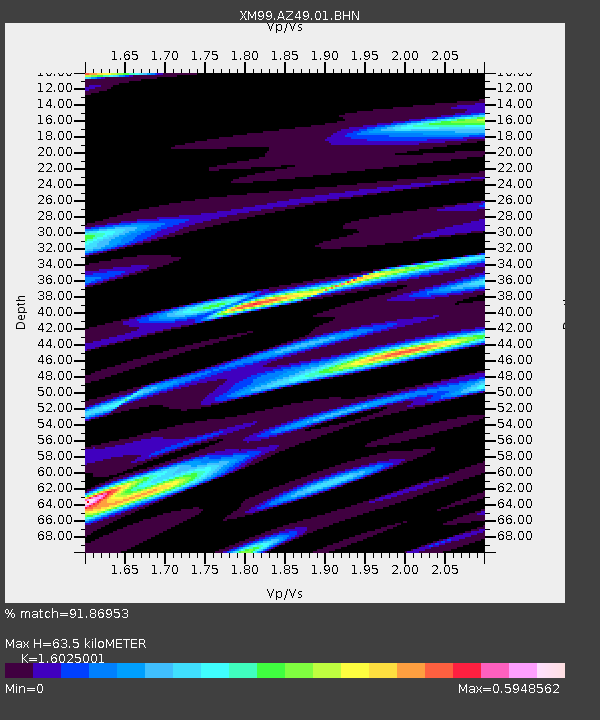
| Estimated Moho Depth: |
63.5 km |
| Estimated Crust Vp/Vs: |
1.60 |
| Assumed Crust Vp: |
6.476 km/s |
| Estimated Crust Vs: |
4.041 km/s |
| Estimated Crust Poisson's Ratio: |
0.18 |
|
| Radial Match: |
91.86953 % |
| Radial Bump: |
400 |
| Transverse Match: |
83.956436 % |
| Transverse Bump: |
400 |
| SOD ConfigId: |
16820 |
| Insert Time: |
2010-02-26 17:20:02.673 +0000 |
| GWidth: |
2.5 |
| Max Bumps: |
400 |
| Tol: |
0.001 |
|

Signal To Noise
| Channel | StoN | STA | LTA |
| XM:AZ49:01:BHN:20000928T23:31:31.765009Z | 1.4909809 | 1.1844247E-7 | 7.94393E-8 |
| XM:AZ49:01:BHE:20000928T23:31:31.765009Z | 0.7664536 | 7.326581E-8 | 9.559066E-8 |
| XM:AZ49:01:BHZ:20000928T23:31:31.765009Z | 1.6496658 | 1.943167E-7 | 1.1779155E-7 |
| Arrivals |
| Ps | 6.3 SECOND |
| PpPs | 24 SECOND |
| PsPs/PpSs | 30 SECOND |


