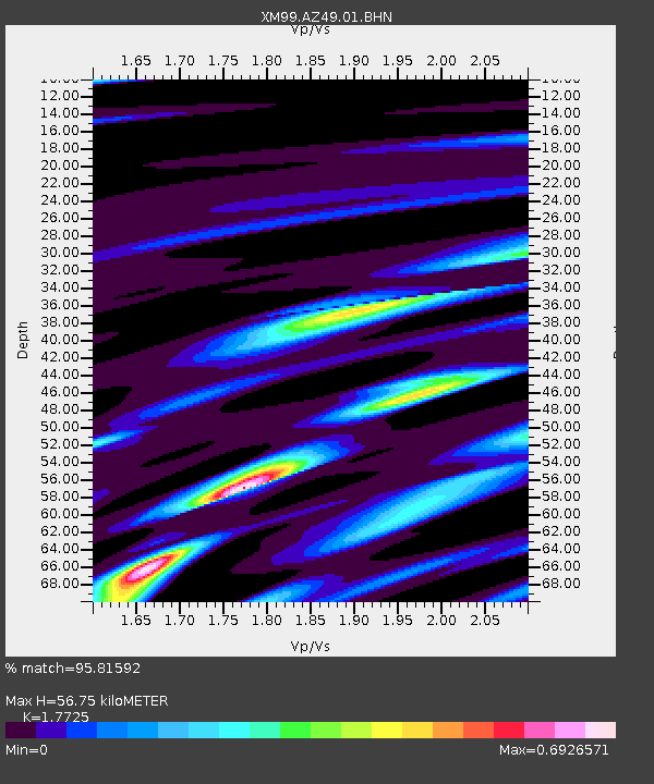
AZ49 Arizona49 - Earthquake Result Viewer
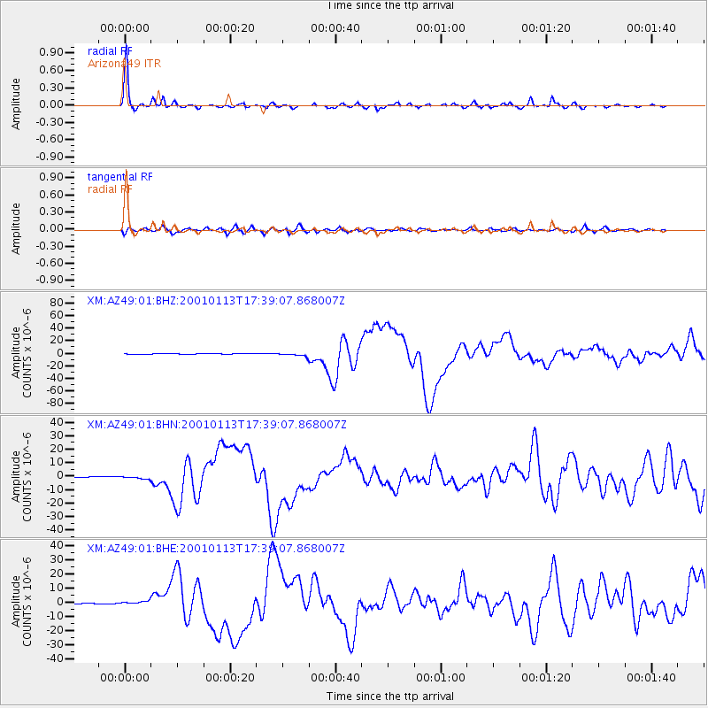
Earthquake location: El Salvador
Earthquake latitude/longitude: 13.0/-88.7
Earthquake time(UTC): 2001/01/13 (013) 17:33:32 GMT
Earthquake Depth: 60 km
Earthquake Magnitude: 6.4 MB, 7.8 MS, 7.7 MW, 7.5 ME
Earthquake Catalog/Contributor: WHDF/NEIC
Network: XM Rio Grande Seismic Transect
Station: AZ49 Arizona49
Lat/Lon: 36.89 N/109.69 W
Elevation: 1512 m
Distance: 30.3 deg
Az: 325.235 deg
Baz: 136.126 deg
Ray Param: 0.079283245
Estimated Moho Depth: 56.75 km
Estimated Crust Vp/Vs: 1.77
Assumed Crust Vp: 6.476 km/s
Estimated Crust Vs: 3.654 km/s
Estimated Crust Poisson's Ratio: 0.27
Radial Match: 95.81592 %
Radial Bump: 250
Transverse Match: 82.99551 %
Transverse Bump: 400
SOD ConfigId: 16820
Insert Time: 2010-02-26 17:20:05.960 +0000
GWidth: 2.5
Max Bumps: 400
Tol: 0.001

Signal To Noise

ChannelStoNSTALTA
XM:AZ49:01:BHN:20010113T17:39:07.868007Z1.94221699.229377E-74.7519808E-7
XM:AZ49:01:BHE:20010113T17:39:07.868007Z3.37071041.1714835E-63.4754797E-7
XM:AZ49:01:BHZ:20010113T17:39:07.868007Z6.58519942.7540202E-64.1821366E-7
Arrivals
Ps7.3 SECOND
PpPs22 SECOND
PsPs/PpSs30 SECOND