You are here: Home > Network List > AK - Alaska Regional Network Stations List
> Station C16K Lisburne Hills, AK, USA > Earthquake Result Viewer
C16K Lisburne Hills, AK, USA - Earthquake Result Viewer
| Earthquake location: |
Southeast Of Loyalty Islands |
| Earthquake latitude/longitude: |
-22.7/170.3 |
| Earthquake time(UTC): |
2022/03/30 (089) 20:56:58 GMT |
| Earthquake Depth: |
10 km |
| Earthquake Magnitude: |
6.7 mww |
| Earthquake Catalog/Contributor: |
NEIC PDE/us |
|
| Network: |
AK Alaska Regional Network |
| Station: |
C16K Lisburne Hills, AK, USA |
| Lat/Lon: |
68.27 N/165.34 W |
| Elevation: |
102 m |
|
| Distance: |
92.5 deg |
| Az: |
8.849 deg |
| Baz: |
202.426 deg |
| Ray Param: |
0.041450772 |
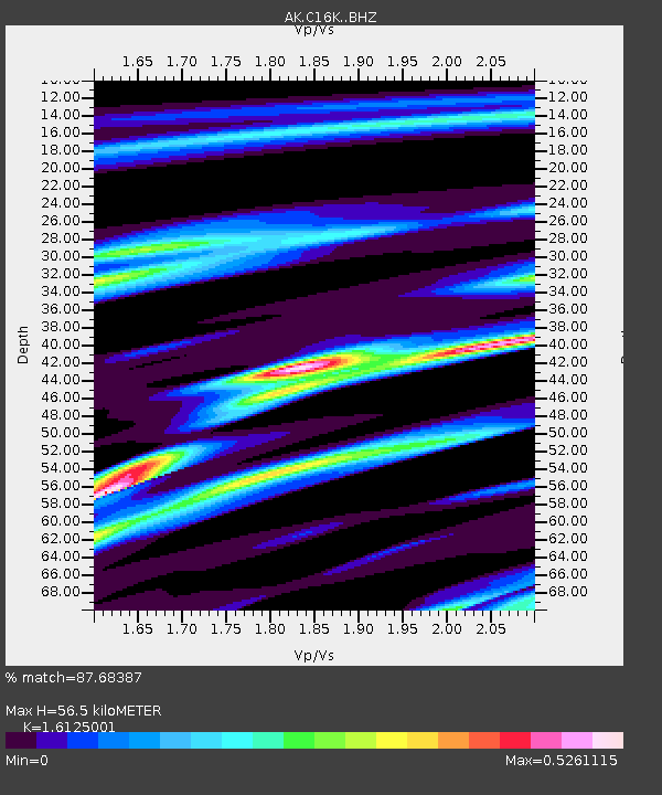
| Estimated Moho Depth: |
56.5 km |
| Estimated Crust Vp/Vs: |
1.61 |
| Assumed Crust Vp: |
5.906 km/s |
| Estimated Crust Vs: |
3.663 km/s |
| Estimated Crust Poisson's Ratio: |
0.19 |
|
| Radial Match: |
87.68387 % |
| Radial Bump: |
342 |
| Transverse Match: |
70.014114 % |
| Transverse Bump: |
400 |
| SOD ConfigId: |
27527651 |
| Insert Time: |
2022-04-13 20:58:45.545 +0000 |
| GWidth: |
2.5 |
| Max Bumps: |
400 |
| Tol: |
0.001 |
|

Signal To Noise
| Channel | StoN | STA | LTA |
| AK:C16K: :BHZ:20220330T21:09:38.420018Z | 2.1392884 | 5.5434737E-7 | 2.5912698E-7 |
| AK:C16K: :BHN:20220330T21:09:38.420018Z | 0.9575624 | 1.617383E-7 | 1.6890627E-7 |
| AK:C16K: :BHE:20220330T21:09:38.420018Z | 0.6475331 | 7.463805E-8 | 1.1526522E-7 |
| Arrivals |
| Ps | 6.0 SECOND |
| PpPs | 25 SECOND |
| PsPs/PpSs | 30 SECOND |


