You are here: Home > Network List > XE05 - Sierra Nevada EarthScope Project- EarthScope Flex Array Stations List
> Station SNPB6 SNPB6 > Earthquake Result Viewer
SNPB6 SNPB6 - Earthquake Result Viewer
| Earthquake location: |
Kuril Islands |
| Earthquake latitude/longitude: |
46.9/153.7 |
| Earthquake time(UTC): |
2006/11/15 (319) 11:33:23 GMT |
| Earthquake Depth: |
10 km |
| Earthquake Magnitude: |
5.5 MB |
| Earthquake Catalog/Contributor: |
WHDF/NEIC |
|
| Network: |
XE Sierra Nevada EarthScope Project- EarthScope Flex Array |
| Station: |
SNPB6 SNPB6 |
| Lat/Lon: |
38.88 N/120.27 W |
| Elevation: |
2230 m |
|
| Distance: |
60.5 deg |
| Az: |
63.426 deg |
| Baz: |
308.156 deg |
| Ray Param: |
0.061477046 |
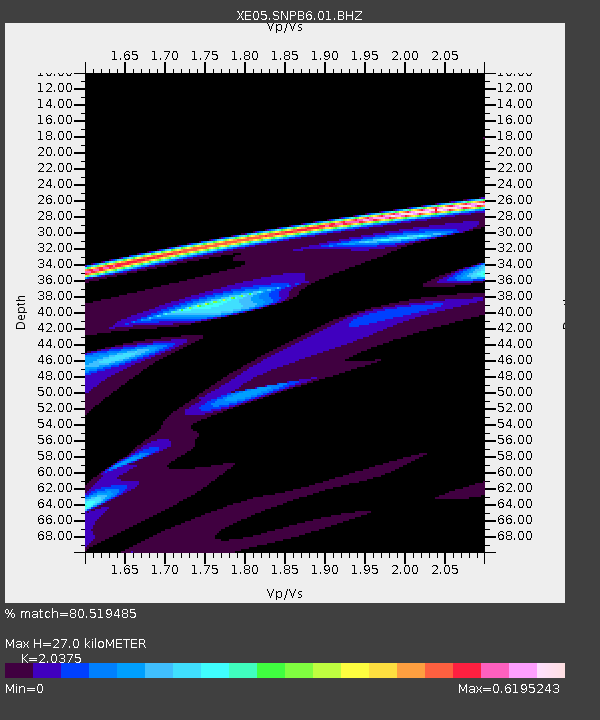
| Estimated Moho Depth: |
27.0 km |
| Estimated Crust Vp/Vs: |
2.04 |
| Assumed Crust Vp: |
6.597 km/s |
| Estimated Crust Vs: |
3.238 km/s |
| Estimated Crust Poisson's Ratio: |
0.34 |
|
| Radial Match: |
80.519485 % |
| Radial Bump: |
400 |
| Transverse Match: |
69.73982 % |
| Transverse Bump: |
400 |
| SOD ConfigId: |
268666 |
| Insert Time: |
2010-03-09 18:05:47.275 +0000 |
| GWidth: |
2.5 |
| Max Bumps: |
400 |
| Tol: |
0.001 |
|

Signal To Noise
| Channel | StoN | STA | LTA |
| XE:SNPB6:01:BHZ:20061115T11:43:02.914014Z | 5.6374564 | 6.870433E-5 | 1.2187115E-5 |
| XE:SNPB6:01:BHN:20061115T11:43:02.914014Z | 0.07688782 | 3.226205E-6 | 4.19599E-5 |
| XE:SNPB6:01:BHE:20061115T11:43:02.914014Z | 1.2672534 | 3.902465E-5 | 3.079467E-5 |
| Arrivals |
| Ps | 4.4 SECOND |
| PpPs | 12 SECOND |
| PsPs/PpSs | 16 SECOND |


