You are here: Home > Network List > AV - Alaska Volcano Observatory Stations List
> Station KARR Katmai Rainbow River, Alaska > Earthquake Result Viewer
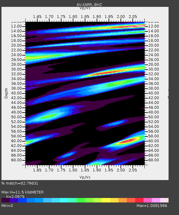
KARR Katmai Rainbow River, Alaska - Earthquake Result Viewer
| Earthquake location: |
Southeast Of Loyalty Islands |
| Earthquake latitude/longitude: |
-22.7/170.3 |
| Earthquake time(UTC): |
2022/03/30 (089) 20:56:58 GMT |
| Earthquake Depth: |
10 km |
| Earthquake Magnitude: |
6.7 mww |
| Earthquake Catalog/Contributor: |
NEIC PDE/us |
|
| Network: |
AV Alaska Volcano Observatory |
| Station: |
KARR Katmai Rainbow River, Alaska |
| Lat/Lon: |
58.50 N/154.71 W |
| Elevation: |
610 m |
|
| Distance: |
86.0 deg |
| Az: |
17.581 deg |
| Baz: |
212.083 deg |
| Ray Param: |
0.04438824 |
| Estimated Moho Depth: |
11.5 km |
| Estimated Crust Vp/Vs: |
2.10 |
| Assumed Crust Vp: |
6.438 km/s |
| Estimated Crust Vs: |
3.069 km/s |
| Estimated Crust Poisson's Ratio: |
0.35 |
|
| Radial Match: |
82.79631 % |
| Radial Bump: |
400 |
| Transverse Match: |
70.4622 % |
| Transverse Bump: |
400 |
| SOD ConfigId: |
27527651 |
| Insert Time: |
2022-04-13 21:03:43.489 +0000 |
| GWidth: |
2.5 |
| Max Bumps: |
400 |
| Tol: |
0.001 |
|

Signal To Noise
| Channel | StoN | STA | LTA |
| AV:KARR: :BHZ:20220330T21:09:07.759984Z | 6.1985145 | 9.200962E-7 | 1.4843818E-7 |
| AV:KARR: :BHN:20220330T21:09:07.759984Z | 1.7007606 | 3.3885445E-7 | 1.9923701E-7 |
| AV:KARR: :BHE:20220330T21:09:07.759984Z | 1.1514584 | 2.2569955E-7 | 1.960119E-7 |
| Arrivals |
| Ps | 2.0 SECOND |
| PpPs | 5.4 SECOND |
| PsPs/PpSs | 7.4 SECOND |


