You are here: Home > Network List > XM99 - Rio Grande Seismic Transect Stations List
> Station AZ49 Arizona49 > Earthquake Result Viewer
AZ49 Arizona49 - Earthquake Result Viewer
| Earthquake location: |
Near Coast Of Ecuador |
| Earthquake latitude/longitude: |
-3.5/-79.2 |
| Earthquake time(UTC): |
1999/08/03 (215) 15:58:57 GMT |
| Earthquake Depth: |
88 km |
| Earthquake Magnitude: |
5.7 MB, 5.0 MS, 5.9 MW, 5.9 MW |
| Earthquake Catalog/Contributor: |
WHDF/NEIC |
|
| Network: |
XM Rio Grande Seismic Transect |
| Station: |
AZ49 Arizona49 |
| Lat/Lon: |
36.89 N/109.69 W |
| Elevation: |
1512 m |
|
| Distance: |
49.2 deg |
| Az: |
327.444 deg |
| Baz: |
137.934 deg |
| Ray Param: |
0.068587124 |
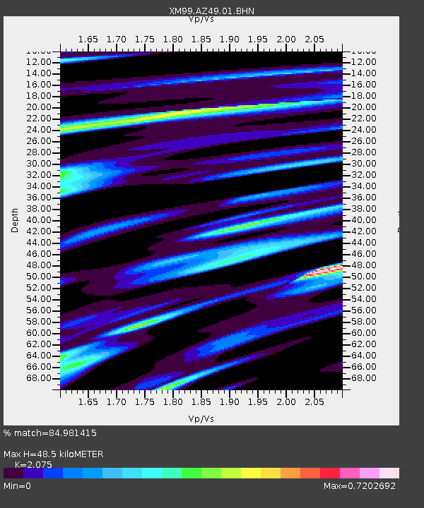
| Estimated Moho Depth: |
48.5 km |
| Estimated Crust Vp/Vs: |
2.08 |
| Assumed Crust Vp: |
6.476 km/s |
| Estimated Crust Vs: |
3.121 km/s |
| Estimated Crust Poisson's Ratio: |
0.35 |
|
| Radial Match: |
84.981415 % |
| Radial Bump: |
400 |
| Transverse Match: |
69.78879 % |
| Transverse Bump: |
400 |
| SOD ConfigId: |
27569 |
| Insert Time: |
2010-02-26 17:20:10.749 +0000 |
| GWidth: |
2.5 |
| Max Bumps: |
400 |
| Tol: |
0.001 |
|
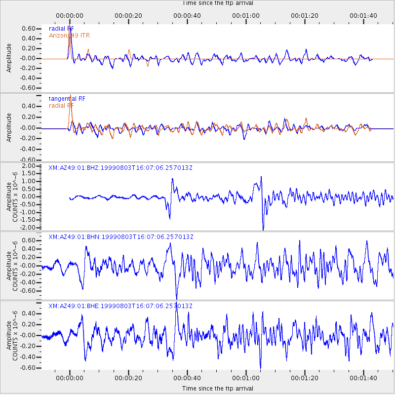
Signal To Noise
| Channel | StoN | STA | LTA |
| XM:AZ49:01:BHN:19990803T16:07:06.257013Z | 2.851132 | 2.2455055E-7 | 7.875838E-8 |
| XM:AZ49:01:BHE:19990803T16:07:06.257013Z | 2.3012297 | 1.6020843E-7 | 6.9618615E-8 |
| XM:AZ49:01:BHZ:19990803T16:07:06.257013Z | 6.2866206 | 4.805618E-7 | 7.644199E-8 |
| Arrivals |
| Ps | 8.5 SECOND |
| PpPs | 22 SECOND |
| PsPs/PpSs | 30 SECOND |


