You are here: Home > Network List > XM99 - Rio Grande Seismic Transect Stations List
> Station AZ49 Arizona49 > Earthquake Result Viewer
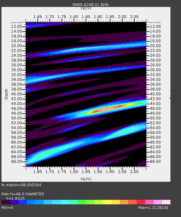
AZ49 Arizona49 - Earthquake Result Viewer
| Earthquake location: |
Northern Chile |
| Earthquake latitude/longitude: |
-18.9/-69.2 |
| Earthquake time(UTC): |
1999/11/30 (334) 04:01:53 GMT |
| Earthquake Depth: |
128 km |
| Earthquake Magnitude: |
6.2 MB, 6.6 MW, 6.5 MW |
| Earthquake Catalog/Contributor: |
WHDF/NEIC |
|
| Network: |
XM Rio Grande Seismic Transect |
| Station: |
AZ49 Arizona49 |
| Lat/Lon: |
36.89 N/109.69 W |
| Elevation: |
1512 m |
|
| Distance: |
67.4 deg |
| Az: |
325.646 deg |
| Baz: |
138.213 deg |
| Ray Param: |
0.056648947 |
| Estimated Moho Depth: |
46.0 km |
| Estimated Crust Vp/Vs: |
1.93 |
| Assumed Crust Vp: |
6.476 km/s |
| Estimated Crust Vs: |
3.351 km/s |
| Estimated Crust Poisson's Ratio: |
0.32 |
|
| Radial Match: |
86.050354 % |
| Radial Bump: |
400 |
| Transverse Match: |
68.15103 % |
| Transverse Bump: |
400 |
| SOD ConfigId: |
27569 |
| Insert Time: |
2010-02-26 17:20:14.082 +0000 |
| GWidth: |
2.5 |
| Max Bumps: |
400 |
| Tol: |
0.001 |
|

Signal To Noise
| Channel | StoN | STA | LTA |
| XM:AZ49:01:BHN:19991130T04:12:03.912017Z | 5.2548537 | 5.1880545E-7 | 9.8728805E-8 |
| XM:AZ49:01:BHE:19991130T04:12:03.912017Z | 2.3933694 | 6.5104825E-7 | 2.7202162E-7 |
| XM:AZ49:01:BHZ:19991130T04:12:03.912017Z | 10.12652 | 1.444457E-6 | 1.42641E-7 |
| Arrivals |
| Ps | 6.9 SECOND |
| PpPs | 20 SECOND |
| PsPs/PpSs | 27 SECOND |


