You are here: Home > Network List > US - United States National Seismic Network Stations List
> Station MNTX Cornudas Mountains, Texas, USA > Earthquake Result Viewer
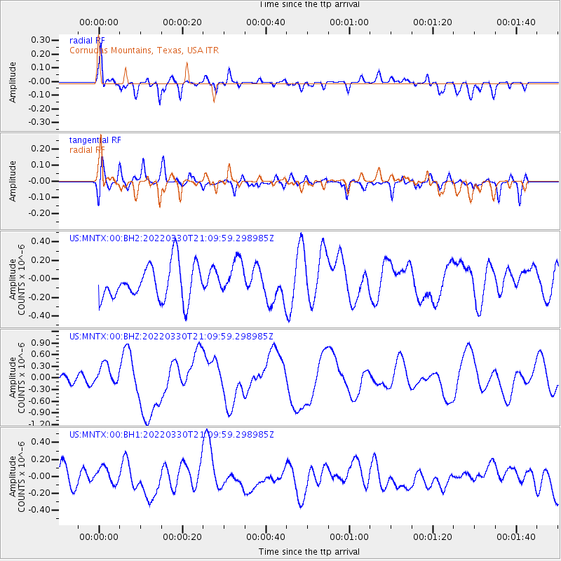
MNTX Cornudas Mountains, Texas, USA - Earthquake Result Viewer
*The percent match for this event was below the threshold and hence no stack was calculated.
| Earthquake location: |
Southeast Of Loyalty Islands |
| Earthquake latitude/longitude: |
-22.7/170.3 |
| Earthquake time(UTC): |
2022/03/30 (089) 20:56:58 GMT |
| Earthquake Depth: |
10 km |
| Earthquake Magnitude: |
6.7 mww |
| Earthquake Catalog/Contributor: |
NEIC PDE/us |
|
| Network: |
US United States National Seismic Network |
| Station: |
MNTX Cornudas Mountains, Texas, USA |
| Lat/Lon: |
31.70 N/105.38 W |
| Elevation: |
405 m |
|
| Distance: |
97.1 deg |
| Az: |
58.733 deg |
| Baz: |
247.801 deg |
| Ray Param: |
$rayparam |
*The percent match for this event was below the threshold and hence was not used in the summary stack. |
|
| Radial Match: |
65.29319 % |
| Radial Bump: |
400 |
| Transverse Match: |
47.65974 % |
| Transverse Bump: |
400 |
| SOD ConfigId: |
27527651 |
| Insert Time: |
2022-04-13 21:15:10.756 +0000 |
| GWidth: |
2.5 |
| Max Bumps: |
400 |
| Tol: |
0.001 |
|
Signal To Noise
| Channel | StoN | STA | LTA |
| US:MNTX:00:BHZ:20220330T21:09:59.298985Z | 2.6985834 | 2.6791164E-7 | 9.927862E-8 |
| US:MNTX:00:BH1:20220330T21:09:59.298985Z | 1.0268551 | 1.2060399E-7 | 1.1744986E-7 |
| US:MNTX:00:BH2:20220330T21:09:59.298985Z | 1.0055016 | 1.9072182E-7 | 1.8967829E-7 |
| Arrivals |
| Ps | |
| PpPs | |
| PsPs/PpSs | |


