You are here: Home > Network List > XM99 - Rio Grande Seismic Transect Stations List
> Station AZ49 Arizona49 > Earthquake Result Viewer
AZ49 Arizona49 - Earthquake Result Viewer
| Earthquake location: |
Alaska Peninsula |
| Earthquake latitude/longitude: |
54.7/-161.2 |
| Earthquake time(UTC): |
1999/10/13 (286) 01:33:40 GMT |
| Earthquake Depth: |
30 km |
| Earthquake Magnitude: |
6.0 MB, 6.2 MS, 6.5 MW, 6.0 ML |
| Earthquake Catalog/Contributor: |
WHDF/NEIC |
|
| Network: |
XM Rio Grande Seismic Transect |
| Station: |
AZ49 Arizona49 |
| Lat/Lon: |
36.89 N/109.69 W |
| Elevation: |
1512 m |
|
| Distance: |
39.1 deg |
| Az: |
95.367 deg |
| Baz: |
313.817 deg |
| Ray Param: |
0.07514516 |
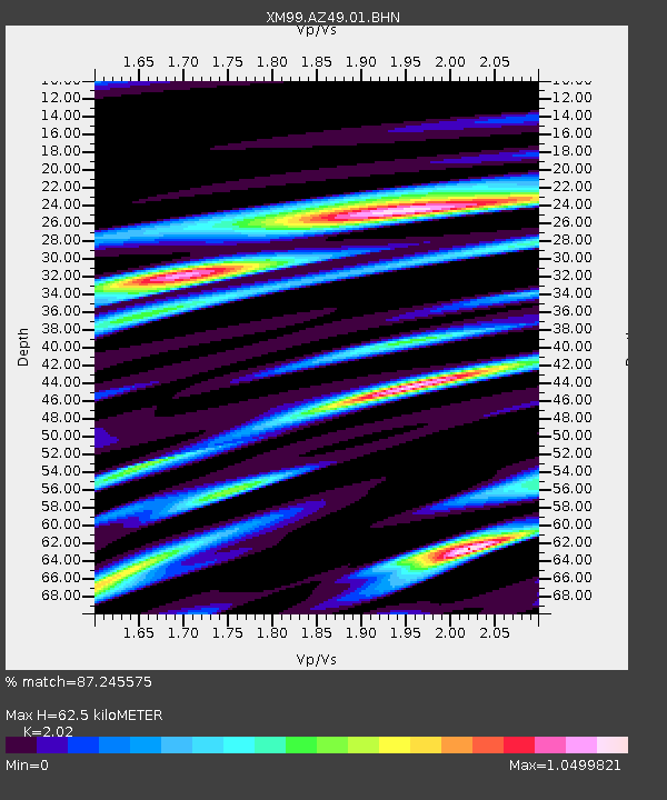
| Estimated Moho Depth: |
62.5 km |
| Estimated Crust Vp/Vs: |
2.02 |
| Assumed Crust Vp: |
6.476 km/s |
| Estimated Crust Vs: |
3.206 km/s |
| Estimated Crust Poisson's Ratio: |
0.34 |
|
| Radial Match: |
87.245575 % |
| Radial Bump: |
400 |
| Transverse Match: |
71.66483 % |
| Transverse Bump: |
400 |
| SOD ConfigId: |
27569 |
| Insert Time: |
2010-02-26 17:20:15.178 +0000 |
| GWidth: |
2.5 |
| Max Bumps: |
400 |
| Tol: |
0.001 |
|

Signal To Noise
| Channel | StoN | STA | LTA |
| XM:AZ49:01:BHN:19991013T01:40:33.808986Z | 1.6529143 | 1.7997009E-7 | 1.0888047E-7 |
| XM:AZ49:01:BHE:19991013T01:40:33.808986Z | 2.6317694 | 2.9565297E-7 | 1.12340004E-7 |
| XM:AZ49:01:BHZ:19991013T01:40:33.808986Z | 3.4322414 | 4.086329E-7 | 1.19057155E-7 |
| Arrivals |
| Ps | 10 SECOND |
| PpPs | 27 SECOND |
| PsPs/PpSs | 38 SECOND |


