You are here: Home > Network List > XM99 - Rio Grande Seismic Transect Stations List
> Station AZ49 Arizona49 > Earthquake Result Viewer
AZ49 Arizona49 - Earthquake Result Viewer
| Earthquake location: |
Ecuador |
| Earthquake latitude/longitude: |
-1.3/-77.5 |
| Earthquake time(UTC): |
1999/08/28 (240) 12:40:06 GMT |
| Earthquake Depth: |
196 km |
| Earthquake Magnitude: |
5.9 MB, 6.3 MW, 6.2 MW |
| Earthquake Catalog/Contributor: |
WHDF/NEIC |
|
| Network: |
XM Rio Grande Seismic Transect |
| Station: |
AZ49 Arizona49 |
| Lat/Lon: |
36.89 N/109.69 W |
| Elevation: |
1512 m |
|
| Distance: |
48.3 deg |
| Az: |
325.153 deg |
| Baz: |
134.562 deg |
| Ray Param: |
0.06871522 |
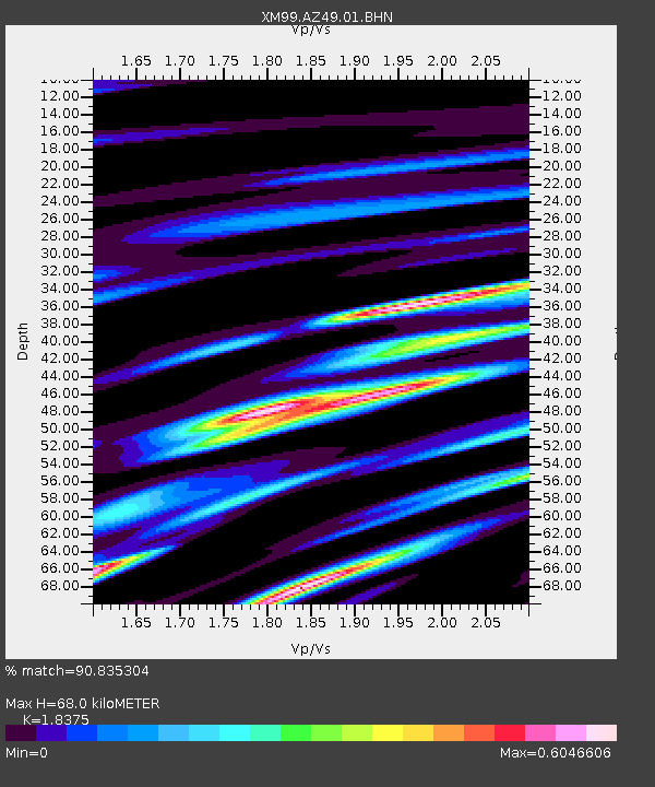
| Estimated Moho Depth: |
68.0 km |
| Estimated Crust Vp/Vs: |
1.84 |
| Assumed Crust Vp: |
6.476 km/s |
| Estimated Crust Vs: |
3.524 km/s |
| Estimated Crust Poisson's Ratio: |
0.29 |
|
| Radial Match: |
90.835304 % |
| Radial Bump: |
400 |
| Transverse Match: |
84.492676 % |
| Transverse Bump: |
400 |
| SOD ConfigId: |
27569 |
| Insert Time: |
2010-02-26 17:20:18.267 +0000 |
| GWidth: |
2.5 |
| Max Bumps: |
400 |
| Tol: |
0.001 |
|

Signal To Noise
| Channel | StoN | STA | LTA |
| XM:AZ49:01:BHN:19990828T12:47:56.906003Z | 8.943419 | 7.848314E-7 | 8.7755176E-8 |
| XM:AZ49:01:BHE:19990828T12:47:56.906003Z | 17.236595 | 8.4297176E-7 | 4.890593E-8 |
| XM:AZ49:01:BHZ:19990828T12:47:56.906003Z | 27.153856 | 2.1605813E-6 | 7.956812E-8 |
| Arrivals |
| Ps | 9.3 SECOND |
| PpPs | 28 SECOND |
| PsPs/PpSs | 37 SECOND |


