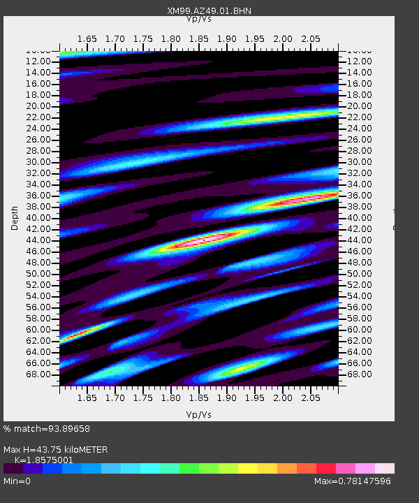
AZ49 Arizona49 - Earthquake Result Viewer

Earthquake location: Off Coast Of Southern Chile
Earthquake latitude/longitude: -40.5/-74.8
Earthquake time(UTC): 1999/08/22 (234) 09:35:39 GMT
Earthquake Depth: 33 km
Earthquake Magnitude: 6.2 MB, 5.8 MS, 6.4 MW, 6.2 MW
Earthquake Catalog/Contributor: WHDF/NEIC
Network: XM Rio Grande Seismic Transect
Station: AZ49 Arizona49
Lat/Lon: 36.89 N/109.69 W
Elevation: 1512 m
Distance: 83.4 deg
Az: 332.473 deg
Baz: 153.928 deg
Ray Param: 0.04615032
Estimated Moho Depth: 43.75 km
Estimated Crust Vp/Vs: 1.86
Assumed Crust Vp: 6.476 km/s
Estimated Crust Vs: 3.486 km/s
Estimated Crust Poisson's Ratio: 0.30
Radial Match: 93.89658 %
Radial Bump: 400
Transverse Match: 83.59841 %
Transverse Bump: 400
SOD ConfigId: 27569
Insert Time: 2010-02-26 17:20:20.935 +0000
GWidth: 2.5
Max Bumps: 400
Tol: 0.001

Signal To Noise

ChannelStoNSTALTA
XM:AZ49:01:BHN:19990822T09:47:32.404998Z8.6776036.464946E-77.450152E-8
XM:AZ49:01:BHE:19990822T09:47:32.404998Z4.78497364.3191255E-79.026436E-8
XM:AZ49:01:BHZ:19990822T09:47:32.404998Z26.568341.9892557E-67.487317E-8
Arrivals
Ps5.9 SECOND
PpPs19 SECOND
PsPs/PpSs25 SECOND