You are here: Home > Network List > CN - Canadian National Seismograph Network Stations List
> Station NLLB Nanaimo Lost Lake, BC, CA > Earthquake Result Viewer
NLLB Nanaimo Lost Lake, BC, CA - Earthquake Result Viewer
| Earthquake location: |
Southeast Of Loyalty Islands |
| Earthquake latitude/longitude: |
-22.7/170.3 |
| Earthquake time(UTC): |
2022/03/31 (090) 05:44:01 GMT |
| Earthquake Depth: |
10 km |
| Earthquake Magnitude: |
7.2 Mi |
| Earthquake Catalog/Contributor: |
NEIC PDE/at |
|
| Network: |
CN Canadian National Seismograph Network |
| Station: |
NLLB Nanaimo Lost Lake, BC, CA |
| Lat/Lon: |
49.23 N/123.99 W |
| Elevation: |
199 m |
|
| Distance: |
92.3 deg |
| Az: |
36.73 deg |
| Baz: |
237.396 deg |
| Ray Param: |
0.041475836 |
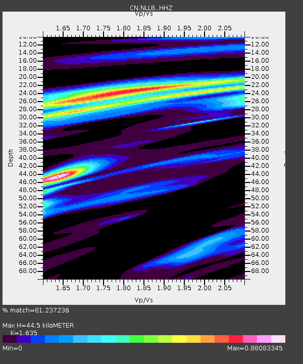
| Estimated Moho Depth: |
44.5 km |
| Estimated Crust Vp/Vs: |
1.63 |
| Assumed Crust Vp: |
6.566 km/s |
| Estimated Crust Vs: |
4.016 km/s |
| Estimated Crust Poisson's Ratio: |
0.20 |
|
| Radial Match: |
81.237236 % |
| Radial Bump: |
400 |
| Transverse Match: |
61.60285 % |
| Transverse Bump: |
365 |
| SOD ConfigId: |
27527651 |
| Insert Time: |
2022-04-14 05:59:26.595 +0000 |
| GWidth: |
2.5 |
| Max Bumps: |
400 |
| Tol: |
0.001 |
|

Signal To Noise
| Channel | StoN | STA | LTA |
| CN:NLLB: :HHZ:20220331T05:56:39.799988Z | 3.100912 | 1.2622E-6 | 4.070415E-7 |
| CN:NLLB: :HHN:20220331T05:56:39.799988Z | 0.5585955 | 2.3855134E-7 | 4.2705565E-7 |
| CN:NLLB: :HHE:20220331T05:56:39.799988Z | 1.2123348 | 6.5197094E-7 | 5.377813E-7 |
| Arrivals |
| Ps | 4.4 SECOND |
| PpPs | 17 SECOND |
| PsPs/PpSs | 22 SECOND |


