You are here: Home > Network List > IW - Intermountain West Stations List
> Station MOOW Moose Ponds, Wyoming, USA > Earthquake Result Viewer
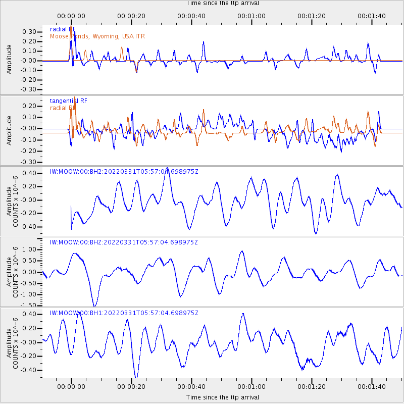
MOOW Moose Ponds, Wyoming, USA - Earthquake Result Viewer
*The percent match for this event was below the threshold and hence no stack was calculated.
| Earthquake location: |
Southeast Of Loyalty Islands |
| Earthquake latitude/longitude: |
-22.7/170.3 |
| Earthquake time(UTC): |
2022/03/31 (090) 05:44:01 GMT |
| Earthquake Depth: |
10 km |
| Earthquake Magnitude: |
7.2 Mi |
| Earthquake Catalog/Contributor: |
NEIC PDE/at |
|
| Network: |
IW Intermountain West |
| Station: |
MOOW Moose Ponds, Wyoming, USA |
| Lat/Lon: |
43.75 N/110.74 W |
| Elevation: |
2128 m |
|
| Distance: |
97.8 deg |
| Az: |
45.887 deg |
| Baz: |
246.188 deg |
| Ray Param: |
$rayparam |
*The percent match for this event was below the threshold and hence was not used in the summary stack. |
|
| Radial Match: |
66.695984 % |
| Radial Bump: |
400 |
| Transverse Match: |
61.325397 % |
| Transverse Bump: |
400 |
| SOD ConfigId: |
27527651 |
| Insert Time: |
2022-04-14 06:02:31.381 +0000 |
| GWidth: |
2.5 |
| Max Bumps: |
400 |
| Tol: |
0.001 |
|
Signal To Noise
| Channel | StoN | STA | LTA |
| IW:MOOW:00:BHZ:20220331T05:57:04.698975Z | 4.189433 | 6.737985E-7 | 1.6083287E-7 |
| IW:MOOW:00:BH1:20220331T05:57:04.698975Z | 2.3616462 | 2.6545277E-7 | 1.1240159E-7 |
| IW:MOOW:00:BH2:20220331T05:57:04.698975Z | 1.9012431 | 3.3079107E-7 | 1.7398673E-7 |
| Arrivals |
| Ps | |
| PpPs | |
| PsPs/PpSs | |


