You are here: Home > Network List > UW - Pacific Northwest Regional Seismic Network Stations List
> Station H2O H2O, Hanford, WA, USA > Earthquake Result Viewer
H2O H2O, Hanford, WA, USA - Earthquake Result Viewer
| Earthquake location: |
Southeast Of Loyalty Islands |
| Earthquake latitude/longitude: |
-22.7/170.3 |
| Earthquake time(UTC): |
2022/03/31 (090) 05:44:01 GMT |
| Earthquake Depth: |
10 km |
| Earthquake Magnitude: |
7.2 Mi |
| Earthquake Catalog/Contributor: |
NEIC PDE/at |
|
| Network: |
UW Pacific Northwest Regional Seismic Network |
| Station: |
H2O H2O, Hanford, WA, USA |
| Lat/Lon: |
46.40 N/119.42 W |
| Elevation: |
175 m |
|
| Distance: |
93.5 deg |
| Az: |
40.747 deg |
| Baz: |
240.565 deg |
| Ray Param: |
0.041252293 |
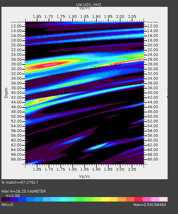
| Estimated Moho Depth: |
26.25 km |
| Estimated Crust Vp/Vs: |
2.08 |
| Assumed Crust Vp: |
6.419 km/s |
| Estimated Crust Vs: |
3.086 km/s |
| Estimated Crust Poisson's Ratio: |
0.35 |
|
| Radial Match: |
87.27617 % |
| Radial Bump: |
351 |
| Transverse Match: |
48.408108 % |
| Transverse Bump: |
400 |
| SOD ConfigId: |
27527651 |
| Insert Time: |
2022-04-14 06:08:56.123 +0000 |
| GWidth: |
2.5 |
| Max Bumps: |
400 |
| Tol: |
0.001 |
|

Signal To Noise
| Channel | StoN | STA | LTA |
| UW:H2O: :HHZ:20220331T05:56:45.210022Z | 4.239529 | 1.3795933E-6 | 3.2541192E-7 |
| UW:H2O: :HHN:20220331T05:56:45.210022Z | 1.4452215 | 2.9519734E-7 | 2.042575E-7 |
| UW:H2O: :HHE:20220331T05:56:45.210022Z | 1.6775522 | 3.6804423E-7 | 2.1939361E-7 |
| Arrivals |
| Ps | 4.5 SECOND |
| PpPs | 12 SECOND |
| PsPs/PpSs | 17 SECOND |


