You are here: Home > Network List > IU - Global Seismograph Network (GSN - IRIS/USGS) Stations List
> Station CTAO Charters Towers, Australia > Earthquake Result Viewer
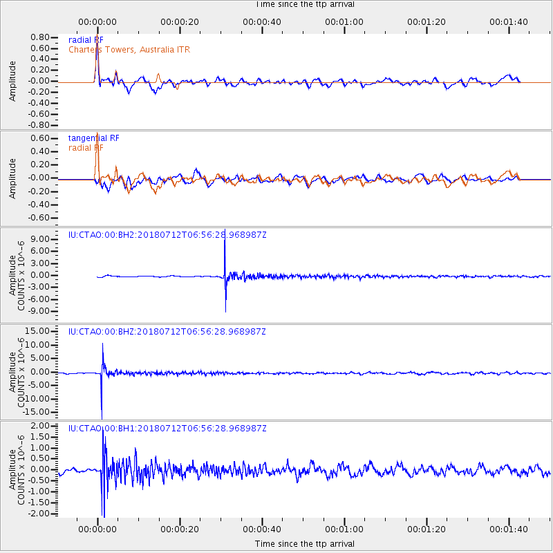
CTAO Charters Towers, Australia - Earthquake Result Viewer
*The percent match for this event was below the threshold and hence no stack was calculated.
| Earthquake location: |
South Of Fiji Islands |
| Earthquake latitude/longitude: |
-23.3/-179.9 |
| Earthquake time(UTC): |
2018/07/12 (193) 06:51:21 GMT |
| Earthquake Depth: |
540 km |
| Earthquake Magnitude: |
5.5 Mww |
| Earthquake Catalog/Contributor: |
NEIC PDE/us |
|
| Network: |
IU Global Seismograph Network (GSN - IRIS/USGS) |
| Station: |
CTAO Charters Towers, Australia |
| Lat/Lon: |
20.09 S/146.25 E |
| Elevation: |
357 m |
|
| Distance: |
31.6 deg |
| Az: |
269.325 deg |
| Baz: |
102.101 deg |
| Ray Param: |
$rayparam |
*The percent match for this event was below the threshold and hence was not used in the summary stack. |
|
| Radial Match: |
75.74573 % |
| Radial Bump: |
400 |
| Transverse Match: |
62.075 % |
| Transverse Bump: |
400 |
| SOD ConfigId: |
2768671 |
| Insert Time: |
2018-07-26 06:56:36.237 +0000 |
| GWidth: |
2.5 |
| Max Bumps: |
400 |
| Tol: |
0.001 |
|
Signal To Noise
| Channel | StoN | STA | LTA |
| IU:CTAO:00:BHZ:20180712T06:56:28.968987Z | 18.355818 | 3.2420896E-6 | 1.7662464E-7 |
| IU:CTAO:00:BH1:20180712T06:56:28.968987Z | 6.276376 | 6.78658E-7 | 1.0812896E-7 |
| IU:CTAO:00:BH2:20180712T06:56:28.968987Z | 17.138813 | 2.275408E-6 | 1.3276346E-7 |
| Arrivals |
| Ps | |
| PpPs | |
| PsPs/PpSs | |


