You are here: Home > Network List > UW - Pacific Northwest Regional Seismic Network Stations List
> Station UMAT Pilot Rock, OR, USA > Earthquake Result Viewer
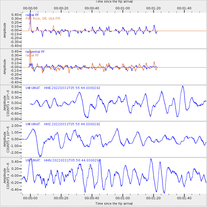
UMAT Pilot Rock, OR, USA - Earthquake Result Viewer
*The percent match for this event was below the threshold and hence no stack was calculated.
| Earthquake location: |
Southeast Of Loyalty Islands |
| Earthquake latitude/longitude: |
-22.7/170.3 |
| Earthquake time(UTC): |
2022/03/31 (090) 05:44:01 GMT |
| Earthquake Depth: |
10 km |
| Earthquake Magnitude: |
7.2 Mi |
| Earthquake Catalog/Contributor: |
NEIC PDE/at |
|
| Network: |
UW Pacific Northwest Regional Seismic Network |
| Station: |
UMAT Pilot Rock, OR, USA |
| Lat/Lon: |
45.29 N/118.96 W |
| Elevation: |
1318 m |
|
| Distance: |
93.3 deg |
| Az: |
41.872 deg |
| Baz: |
240.831 deg |
| Ray Param: |
$rayparam |
*The percent match for this event was below the threshold and hence was not used in the summary stack. |
|
| Radial Match: |
77.30965 % |
| Radial Bump: |
284 |
| Transverse Match: |
56.94716 % |
| Transverse Bump: |
391 |
| SOD ConfigId: |
27527651 |
| Insert Time: |
2022-04-14 06:10:11.446 +0000 |
| GWidth: |
2.5 |
| Max Bumps: |
400 |
| Tol: |
0.001 |
|
Signal To Noise
| Channel | StoN | STA | LTA |
| UW:UMAT: :HHZ:20220331T05:56:44.030029Z | 4.5422125 | 1.1306847E-6 | 2.489282E-7 |
| UW:UMAT: :HHN:20220331T05:56:44.030029Z | 1.9501525 | 2.8652696E-7 | 1.4692542E-7 |
| UW:UMAT: :HHE:20220331T05:56:44.030029Z | 3.1642816 | 4.0100994E-7 | 1.2673016E-7 |
| Arrivals |
| Ps | |
| PpPs | |
| PsPs/PpSs | |


