You are here: Home > Network List > IW - Intermountain West Stations List
> Station PLID Pearl Lake, Idaho, USA > Earthquake Result Viewer
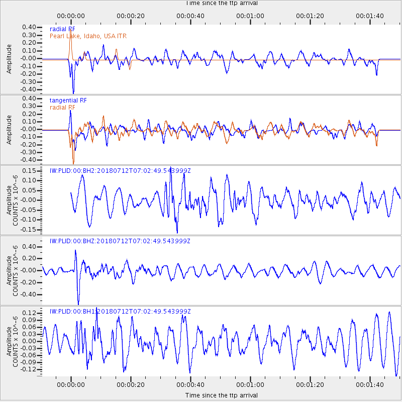
PLID Pearl Lake, Idaho, USA - Earthquake Result Viewer
*The percent match for this event was below the threshold and hence no stack was calculated.
| Earthquake location: |
South Of Fiji Islands |
| Earthquake latitude/longitude: |
-23.3/-179.9 |
| Earthquake time(UTC): |
2018/07/12 (193) 06:51:21 GMT |
| Earthquake Depth: |
540 km |
| Earthquake Magnitude: |
5.5 Mww |
| Earthquake Catalog/Contributor: |
NEIC PDE/us |
|
| Network: |
IW Intermountain West |
| Station: |
PLID Pearl Lake, Idaho, USA |
| Lat/Lon: |
45.09 N/116.00 W |
| Elevation: |
2164 m |
|
| Distance: |
89.5 deg |
| Az: |
39.51 deg |
| Baz: |
235.632 deg |
| Ray Param: |
$rayparam |
*The percent match for this event was below the threshold and hence was not used in the summary stack. |
|
| Radial Match: |
46.13924 % |
| Radial Bump: |
400 |
| Transverse Match: |
50.952507 % |
| Transverse Bump: |
400 |
| SOD ConfigId: |
2768671 |
| Insert Time: |
2018-07-26 06:57:12.525 +0000 |
| GWidth: |
2.5 |
| Max Bumps: |
400 |
| Tol: |
0.001 |
|
Signal To Noise
| Channel | StoN | STA | LTA |
| IW:PLID:00:BHZ:20180712T07:02:49.543999Z | 3.918655 | 2.0897522E-7 | 5.3328307E-8 |
| IW:PLID:00:BH1:20180712T07:02:49.543999Z | 0.8179063 | 4.4996415E-8 | 5.501414E-8 |
| IW:PLID:00:BH2:20180712T07:02:49.543999Z | 1.2185503 | 6.823264E-8 | 5.5994928E-8 |
| Arrivals |
| Ps | |
| PpPs | |
| PsPs/PpSs | |


