You are here: Home > Network List > XE05 - Sierra Nevada EarthScope Project- EarthScope Flex Array Stations List
> Station SNPB9 SNPB9 > Earthquake Result Viewer
SNPB9 SNPB9 - Earthquake Result Viewer
| Earthquake location: |
Fiji Islands Region |
| Earthquake latitude/longitude: |
-21.2/-176.3 |
| Earthquake time(UTC): |
2006/08/15 (227) 23:53:47 GMT |
| Earthquake Depth: |
158 km |
| Earthquake Magnitude: |
5.9 MB, 6.1 MW, 6.1 MW |
| Earthquake Catalog/Contributor: |
WHDF/NEIC |
|
| Network: |
XE Sierra Nevada EarthScope Project- EarthScope Flex Array |
| Station: |
SNPB9 SNPB9 |
| Lat/Lon: |
39.36 N/119.59 W |
| Elevation: |
1855 m |
|
| Distance: |
80.2 deg |
| Az: |
41.097 deg |
| Baz: |
232.302 deg |
| Ray Param: |
0.04807998 |
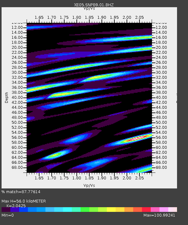
| Estimated Moho Depth: |
56.0 km |
| Estimated Crust Vp/Vs: |
2.04 |
| Assumed Crust Vp: |
6.279 km/s |
| Estimated Crust Vs: |
3.074 km/s |
| Estimated Crust Poisson's Ratio: |
0.34 |
|
| Radial Match: |
87.77614 % |
| Radial Bump: |
400 |
| Transverse Match: |
80.48456 % |
| Transverse Bump: |
400 |
| SOD ConfigId: |
268666 |
| Insert Time: |
2010-03-09 18:13:32.964 +0000 |
| GWidth: |
2.5 |
| Max Bumps: |
400 |
| Tol: |
0.001 |
|

Signal To Noise
| Channel | StoN | STA | LTA |
| XE:SNPB9:01:BHZ:20060816T00:05:08.865Z | 9.848745 | 1.5914233E-8 | 1.6158641E-9 |
| XE:SNPB9:01:BHN:20060816T00:05:08.865Z | 5.3100457 | 5.105593E-7 | 9.61497E-8 |
| XE:SNPB9:01:BHE:20060816T00:05:08.865Z | 3.0361195 | 4.0887295E-7 | 1.3466959E-7 |
| Arrivals |
| Ps | 9.5 SECOND |
| PpPs | 27 SECOND |
| PsPs/PpSs | 36 SECOND |


