You are here: Home > Network List > US - United States National Seismic Network Stations List
> Station MNTX Cornudas Mountains, Texas, USA > Earthquake Result Viewer
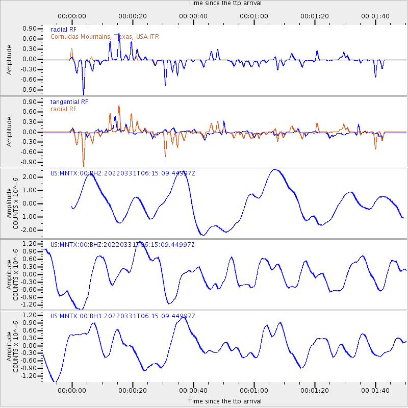
MNTX Cornudas Mountains, Texas, USA - Earthquake Result Viewer
*The percent match for this event was below the threshold and hence no stack was calculated.
| Earthquake location: |
Southeast Of Loyalty Islands |
| Earthquake latitude/longitude: |
-22.5/170.4 |
| Earthquake time(UTC): |
2022/03/31 (090) 06:02:09 GMT |
| Earthquake Depth: |
10 km |
| Earthquake Magnitude: |
5.9 Mww |
| Earthquake Catalog/Contributor: |
NEIC PDE/us |
|
| Network: |
US United States National Seismic Network |
| Station: |
MNTX Cornudas Mountains, Texas, USA |
| Lat/Lon: |
31.70 N/105.38 W |
| Elevation: |
405 m |
|
| Distance: |
96.9 deg |
| Az: |
58.676 deg |
| Baz: |
247.959 deg |
| Ray Param: |
$rayparam |
*The percent match for this event was below the threshold and hence was not used in the summary stack. |
|
| Radial Match: |
79.95917 % |
| Radial Bump: |
311 |
| Transverse Match: |
71.15552 % |
| Transverse Bump: |
340 |
| SOD ConfigId: |
27527651 |
| Insert Time: |
2022-04-14 06:23:49.033 +0000 |
| GWidth: |
2.5 |
| Max Bumps: |
400 |
| Tol: |
0.001 |
|
Signal To Noise
| Channel | StoN | STA | LTA |
| US:MNTX:00:BHZ:20220331T06:15:09.44997Z | 1.338243 | 1.3220598E-6 | 9.879071E-7 |
| US:MNTX:00:BH1:20220331T06:15:09.44997Z | 0.6972441 | 4.2763835E-7 | 6.1332656E-7 |
| US:MNTX:00:BH2:20220331T06:15:09.44997Z | 0.878504 | 9.305017E-7 | 1.0591889E-6 |
| Arrivals |
| Ps | |
| PpPs | |
| PsPs/PpSs | |


