You are here: Home > Network List > AK - Alaska Regional Network Stations List
> Station O18K Koktuh Hills, AK, USA > Earthquake Result Viewer
O18K Koktuh Hills, AK, USA - Earthquake Result Viewer
| Earthquake location: |
Southeast Of Loyalty Islands |
| Earthquake latitude/longitude: |
-22.4/170.3 |
| Earthquake time(UTC): |
2022/03/31 (090) 06:12:25 GMT |
| Earthquake Depth: |
10 km |
| Earthquake Magnitude: |
5.7 mb |
| Earthquake Catalog/Contributor: |
NEIC PDE/us |
|
| Network: |
AK Alaska Regional Network |
| Station: |
O18K Koktuh Hills, AK, USA |
| Lat/Lon: |
59.85 N/155.21 W |
| Elevation: |
544 m |
|
| Distance: |
86.7 deg |
| Az: |
16.641 deg |
| Baz: |
211.679 deg |
| Ray Param: |
0.043891564 |
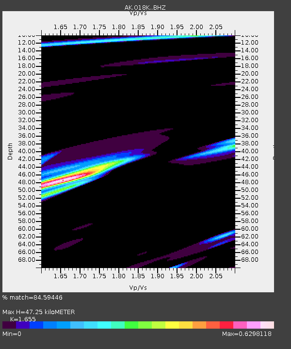
| Estimated Moho Depth: |
47.25 km |
| Estimated Crust Vp/Vs: |
1.65 |
| Assumed Crust Vp: |
6.438 km/s |
| Estimated Crust Vs: |
3.89 km/s |
| Estimated Crust Poisson's Ratio: |
0.21 |
|
| Radial Match: |
84.59446 % |
| Radial Bump: |
398 |
| Transverse Match: |
43.997887 % |
| Transverse Bump: |
332 |
| SOD ConfigId: |
27527651 |
| Insert Time: |
2022-04-14 06:27:46.494 +0000 |
| GWidth: |
2.5 |
| Max Bumps: |
400 |
| Tol: |
0.001 |
|

Signal To Noise
| Channel | StoN | STA | LTA |
| AK:O18K: :BHZ:20220331T06:24:38.019989Z | 3.9497151 | 3.1858906E-6 | 8.066128E-7 |
| AK:O18K: :BHN:20220331T06:24:38.019989Z | 1.9045947 | 1.0110941E-6 | 5.3087103E-7 |
| AK:O18K: :BHE:20220331T06:24:38.019989Z | 0.2893794 | 4.150635E-7 | 1.434323E-6 |
| Arrivals |
| Ps | 4.9 SECOND |
| PpPs | 19 SECOND |
| PsPs/PpSs | 24 SECOND |


