You are here: Home > Network List > AK - Alaska Regional Network Stations List
> Station BAT Barry Arm Top, AK, USA > Earthquake Result Viewer
BAT Barry Arm Top, AK, USA - Earthquake Result Viewer
| Earthquake location: |
Southeast Of Loyalty Islands |
| Earthquake latitude/longitude: |
-22.4/170.3 |
| Earthquake time(UTC): |
2022/03/31 (090) 06:12:25 GMT |
| Earthquake Depth: |
10 km |
| Earthquake Magnitude: |
5.7 mb |
| Earthquake Catalog/Contributor: |
NEIC PDE/us |
|
| Network: |
AK Alaska Regional Network |
| Station: |
BAT Barry Arm Top, AK, USA |
| Lat/Lon: |
61.14 N/148.18 W |
| Elevation: |
1027 m |
|
| Distance: |
89.7 deg |
| Az: |
18.765 deg |
| Baz: |
217.86 deg |
| Ray Param: |
0.041732706 |
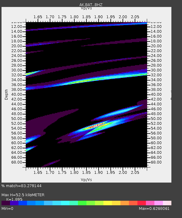
| Estimated Moho Depth: |
52.5 km |
| Estimated Crust Vp/Vs: |
1.89 |
| Assumed Crust Vp: |
6.566 km/s |
| Estimated Crust Vs: |
3.465 km/s |
| Estimated Crust Poisson's Ratio: |
0.31 |
|
| Radial Match: |
83.279144 % |
| Radial Bump: |
400 |
| Transverse Match: |
67.82792 % |
| Transverse Bump: |
400 |
| SOD ConfigId: |
27527651 |
| Insert Time: |
2022-04-14 06:28:24.564 +0000 |
| GWidth: |
2.5 |
| Max Bumps: |
400 |
| Tol: |
0.001 |
|

Signal To Noise
| Channel | StoN | STA | LTA |
| AK:BAT: :BHZ:20220331T06:24:52.480011Z | 0.91779417 | 5.320185E-7 | 5.7967077E-7 |
| AK:BAT: :BHN:20220331T06:24:52.480011Z | 3.1576326 | 1.576263E-6 | 4.9919134E-7 |
| AK:BAT: :BHE:20220331T06:24:52.480011Z | 1.1717249 | 5.222299E-7 | 4.4569327E-7 |
| Arrivals |
| Ps | 7.3 SECOND |
| PpPs | 23 SECOND |
| PsPs/PpSs | 30 SECOND |


