You are here: Home > Network List > CI - Caltech Regional Seismic Network Stations List
> Station ADO Adelanto Receiving Station, Victorville, CA, USA > Earthquake Result Viewer
ADO Adelanto Receiving Station, Victorville, CA, USA - Earthquake Result Viewer
| Earthquake location: |
Southeast Of Loyalty Islands |
| Earthquake latitude/longitude: |
-22.4/170.3 |
| Earthquake time(UTC): |
2022/03/31 (090) 06:12:25 GMT |
| Earthquake Depth: |
10 km |
| Earthquake Magnitude: |
5.7 mb |
| Earthquake Catalog/Contributor: |
NEIC PDE/us |
|
| Network: |
CI Caltech Regional Seismic Network |
| Station: |
ADO Adelanto Receiving Station, Victorville, CA, USA |
| Lat/Lon: |
34.55 N/117.43 W |
| Elevation: |
908 m |
|
| Distance: |
88.9 deg |
| Az: |
51.846 deg |
| Baz: |
241.861 deg |
| Ray Param: |
0.04223377 |
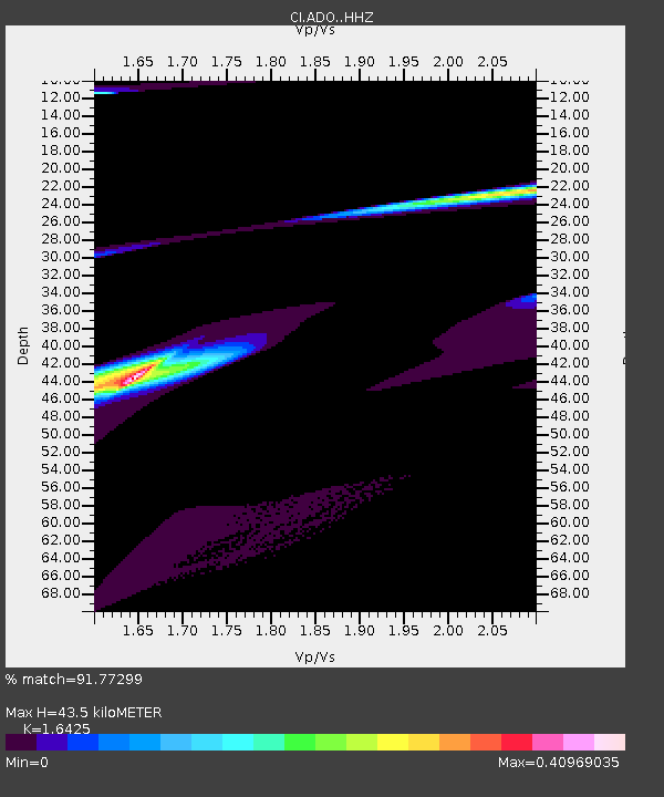
| Estimated Moho Depth: |
43.5 km |
| Estimated Crust Vp/Vs: |
1.64 |
| Assumed Crust Vp: |
6.276 km/s |
| Estimated Crust Vs: |
3.821 km/s |
| Estimated Crust Poisson's Ratio: |
0.21 |
|
| Radial Match: |
91.77299 % |
| Radial Bump: |
400 |
| Transverse Match: |
70.499306 % |
| Transverse Bump: |
400 |
| SOD ConfigId: |
27527651 |
| Insert Time: |
2022-04-14 06:32:16.538 +0000 |
| GWidth: |
2.5 |
| Max Bumps: |
400 |
| Tol: |
0.001 |
|

Signal To Noise
| Channel | StoN | STA | LTA |
| CI:ADO: :HHZ:20220331T06:24:48.787995Z | 2.1567538 | 4.6119135E-6 | 2.138359E-6 |
| CI:ADO: :HHN:20220331T06:24:48.787995Z | 0.4699786 | 5.3621494E-7 | 1.1409347E-6 |
| CI:ADO: :HHE:20220331T06:24:48.787995Z | 1.9318781 | 3.0436252E-6 | 1.5754747E-6 |
| Arrivals |
| Ps | 4.6 SECOND |
| PpPs | 18 SECOND |
| PsPs/PpSs | 22 SECOND |


