You are here: Home > Network List > CI - Caltech Regional Seismic Network Stations List
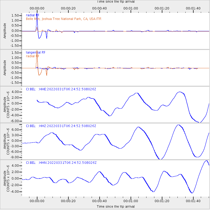
> Station BEL Belle Mtn, Joshua Tree National Park, CA, USA > Earthquake Result Viewer
BEL Belle Mtn, Joshua Tree National Park, CA, USA - Earthquake Result Viewer
| Earthquake location: |
Southeast Of Loyalty Islands |
| Earthquake latitude/longitude: |
-22.4/170.3 |
| Earthquake time(UTC): |
2022/03/31 (090) 06:12:25 GMT |
| Earthquake Depth: |
10 km |
| Earthquake Magnitude: |
5.7 mb |
| Earthquake Catalog/Contributor: |
NEIC PDE/us |
|
| Network: |
CI Caltech Regional Seismic Network |
| Station: |
BEL Belle Mtn, Joshua Tree National Park, CA, USA |
| Lat/Lon: |
34.00 N/116.00 W |
| Elevation: |
1388 m |
|
| Distance: |
89.7 deg |
| Az: |
52.885 deg |
| Baz: |
242.678 deg |
| Ray Param: |
0.041732617 |
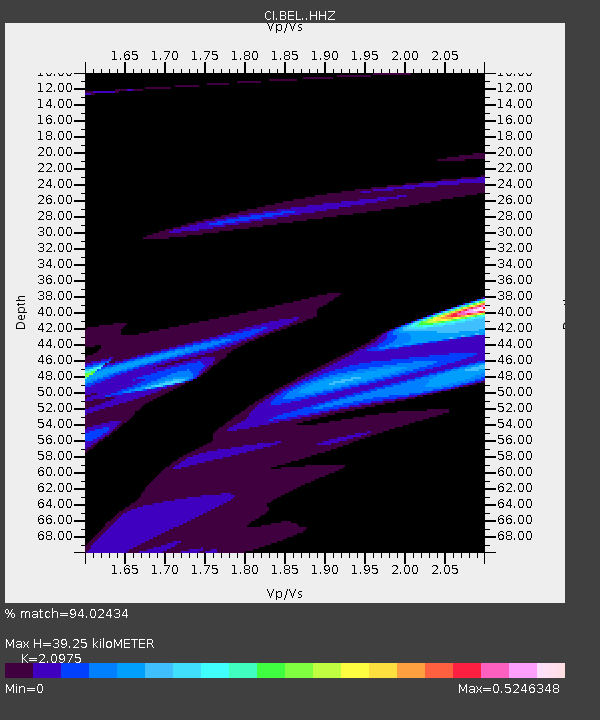
| Estimated Moho Depth: |
39.25 km |
| Estimated Crust Vp/Vs: |
2.10 |
| Assumed Crust Vp: |
6.276 km/s |
| Estimated Crust Vs: |
2.992 km/s |
| Estimated Crust Poisson's Ratio: |
0.35 |
|
| Radial Match: |
94.02434 % |
| Radial Bump: |
400 |
| Transverse Match: |
39.366394 % |
| Transverse Bump: |
295 |
| SOD ConfigId: |
27527651 |
| Insert Time: |
2022-04-14 06:32:23.770 +0000 |
| GWidth: |
2.5 |
| Max Bumps: |
400 |
| Tol: |
0.001 |
|
Signal To Noise
| Channel | StoN | STA | LTA |
| CI:BEL: :HHZ:20220331T06:24:52.508026Z | 1.2343906 | 1.3419706E-6 | 1.0871523E-6 |
| CI:BEL: :HHN:20220331T06:24:52.508026Z | 0.4582896 | 2.9060556E-7 | 6.3410897E-7 |
| CI:BEL: :HHE:20220331T06:24:52.508026Z | 2.888823 | 2.0203017E-6 | 6.993512E-7 |
| Arrivals |
| Ps | 7.0 SECOND |
| PpPs | 19 SECOND |
| PsPs/PpSs | 26 SECOND |


