You are here: Home > Network List > NN - Western Great Basin/Eastern Sierra Nevada Stations List
> Station PNT Pine Nut, Nevada w84 > Earthquake Result Viewer
PNT Pine Nut, Nevada w84 - Earthquake Result Viewer
| Earthquake location: |
Southeast Of Loyalty Islands |
| Earthquake latitude/longitude: |
-22.4/170.3 |
| Earthquake time(UTC): |
2022/03/31 (090) 06:12:25 GMT |
| Earthquake Depth: |
10 km |
| Earthquake Magnitude: |
5.7 mb |
| Earthquake Catalog/Contributor: |
NEIC PDE/us |
|
| Network: |
NN Western Great Basin/Eastern Sierra Nevada |
| Station: |
PNT Pine Nut, Nevada w84 |
| Lat/Lon: |
39.09 N/119.60 W |
| Elevation: |
2076 m |
|
| Distance: |
89.6 deg |
| Az: |
47.04 deg |
| Baz: |
240.504 deg |
| Ray Param: |
0.04174832 |
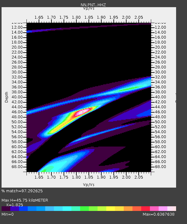
| Estimated Moho Depth: |
45.75 km |
| Estimated Crust Vp/Vs: |
1.83 |
| Assumed Crust Vp: |
6.279 km/s |
| Estimated Crust Vs: |
3.44 km/s |
| Estimated Crust Poisson's Ratio: |
0.29 |
|
| Radial Match: |
97.292625 % |
| Radial Bump: |
371 |
| Transverse Match: |
54.522934 % |
| Transverse Bump: |
400 |
| SOD ConfigId: |
27527651 |
| Insert Time: |
2022-04-14 06:37:05.944 +0000 |
| GWidth: |
2.5 |
| Max Bumps: |
400 |
| Tol: |
0.001 |
|

Signal To Noise
| Channel | StoN | STA | LTA |
| NN:PNT: :HHZ:20220331T06:24:51.873017Z | 3.0805452 | 2.2348975E-6 | 7.254876E-7 |
| NN:PNT: :HHN:20220331T06:24:51.873017Z | 0.5493311 | 5.8567537E-7 | 1.066161E-6 |
| NN:PNT: :HHE:20220331T06:24:51.873017Z | 2.9605014 | 1.6620043E-6 | 5.613928E-7 |
| Arrivals |
| Ps | 6.1 SECOND |
| PpPs | 20 SECOND |
| PsPs/PpSs | 26 SECOND |


