You are here: Home > Network List > AU - Australian Seismological Centre Stations List
> Station PSA00 Pilbara Seismic Array Element A0 > Earthquake Result Viewer
PSA00 Pilbara Seismic Array Element A0 - Earthquake Result Viewer
| Earthquake location: |
Vanuatu Islands |
| Earthquake latitude/longitude: |
-18.9/169.0 |
| Earthquake time(UTC): |
2018/07/13 (194) 09:46:49 GMT |
| Earthquake Depth: |
169 km |
| Earthquake Magnitude: |
6.4 Mww |
| Earthquake Catalog/Contributor: |
NEIC PDE/us |
|
| Network: |
AU Australian Seismological Centre |
| Station: |
PSA00 Pilbara Seismic Array Element A0 |
| Lat/Lon: |
21.57 S/119.85 E |
| Elevation: |
305 m |
|
| Distance: |
46.1 deg |
| Az: |
257.996 deg |
| Baz: |
95.898 deg |
| Ray Param: |
0.07025607 |
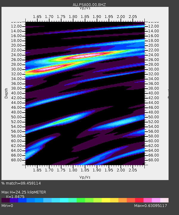
| Estimated Moho Depth: |
24.25 km |
| Estimated Crust Vp/Vs: |
1.85 |
| Assumed Crust Vp: |
6.464 km/s |
| Estimated Crust Vs: |
3.499 km/s |
| Estimated Crust Poisson's Ratio: |
0.29 |
|
| Radial Match: |
89.459114 % |
| Radial Bump: |
341 |
| Transverse Match: |
72.279045 % |
| Transverse Bump: |
400 |
| SOD ConfigId: |
2768671 |
| Insert Time: |
2018-07-27 09:47:22.226 +0000 |
| GWidth: |
2.5 |
| Max Bumps: |
400 |
| Tol: |
0.001 |
|

Signal To Noise
| Channel | StoN | STA | LTA |
| AU:PSA00:00:BHZ:20180713T09:54:25.943986Z | 11.146899 | 5.8034598E-6 | 5.2063444E-7 |
| AU:PSA00:00:BH1:20180713T09:54:25.943986Z | 12.294681 | 3.1881432E-6 | 2.5931078E-7 |
| AU:PSA00:00:BH2:20180713T09:54:25.943986Z | 2.9510083 | 9.4769337E-7 | 3.211422E-7 |
| Arrivals |
| Ps | 3.4 SECOND |
| PpPs | 10 SECOND |
| PsPs/PpSs | 13 SECOND |


