You are here: Home > Network List > UW - Pacific Northwest Regional Seismic Network Stations List
> Station HOOD Mt Hood Meadows, OR CREST BB SMO > Earthquake Result Viewer
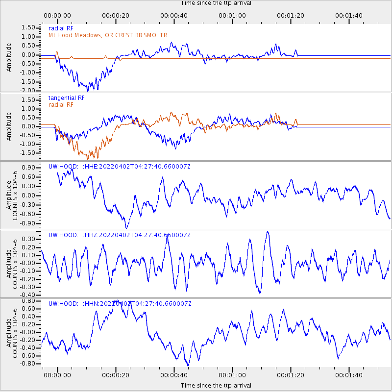
HOOD Mt Hood Meadows, OR CREST BB SMO - Earthquake Result Viewer
*The percent match for this event was below the threshold and hence no stack was calculated.
| Earthquake location: |
Southeast Of Loyalty Islands |
| Earthquake latitude/longitude: |
-22.9/170.5 |
| Earthquake time(UTC): |
2022/04/02 (092) 04:15:04 GMT |
| Earthquake Depth: |
10 km |
| Earthquake Magnitude: |
5.5 Mww |
| Earthquake Catalog/Contributor: |
NEIC PDE/us |
|
| Network: |
UW Pacific Northwest Regional Seismic Network |
| Station: |
HOOD Mt Hood Meadows, OR CREST BB SMO |
| Lat/Lon: |
45.32 N/121.65 W |
| Elevation: |
1520 m |
|
| Distance: |
91.7 deg |
| Az: |
40.812 deg |
| Baz: |
238.659 deg |
| Ray Param: |
$rayparam |
*The percent match for this event was below the threshold and hence was not used in the summary stack. |
|
| Radial Match: |
64.6009 % |
| Radial Bump: |
400 |
| Transverse Match: |
57.83006 % |
| Transverse Bump: |
400 |
| SOD ConfigId: |
27527651 |
| Insert Time: |
2022-04-16 04:28:47.076 +0000 |
| GWidth: |
2.5 |
| Max Bumps: |
400 |
| Tol: |
0.001 |
|
Signal To Noise
| Channel | StoN | STA | LTA |
| UW:HOOD: :HHZ:20220402T04:27:40.660007Z | 0.8870057 | 1.2893186E-7 | 1.453563E-7 |
| UW:HOOD: :HHN:20220402T04:27:40.660007Z | 1.2542832 | 3.3039467E-7 | 2.6341314E-7 |
| UW:HOOD: :HHE:20220402T04:27:40.660007Z | 0.77946365 | 4.2404147E-7 | 5.44017E-7 |
| Arrivals |
| Ps | |
| PpPs | |
| PsPs/PpSs | |


