You are here: Home > Network List > IU - Global Seismograph Network (GSN - IRIS/USGS) Stations List
> Station ULN Ulaanbaatar, Mongolia > Earthquake Result Viewer
ULN Ulaanbaatar, Mongolia - Earthquake Result Viewer
| Earthquake location: |
Vanuatu Islands |
| Earthquake latitude/longitude: |
-18.9/169.0 |
| Earthquake time(UTC): |
2018/07/13 (194) 09:46:49 GMT |
| Earthquake Depth: |
169 km |
| Earthquake Magnitude: |
6.4 Mww |
| Earthquake Catalog/Contributor: |
NEIC PDE/us |
|
| Network: |
IU Global Seismograph Network (GSN - IRIS/USGS) |
| Station: |
ULN Ulaanbaatar, Mongolia |
| Lat/Lon: |
47.87 N/107.05 E |
| Elevation: |
1610 m |
|
| Distance: |
86.5 deg |
| Az: |
323.453 deg |
| Baz: |
123.166 deg |
| Ray Param: |
0.04361801 |
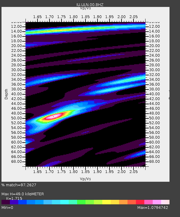
| Estimated Moho Depth: |
49.0 km |
| Estimated Crust Vp/Vs: |
1.72 |
| Assumed Crust Vp: |
6.642 km/s |
| Estimated Crust Vs: |
3.873 km/s |
| Estimated Crust Poisson's Ratio: |
0.24 |
|
| Radial Match: |
97.2627 % |
| Radial Bump: |
354 |
| Transverse Match: |
87.93053 % |
| Transverse Bump: |
400 |
| SOD ConfigId: |
2768671 |
| Insert Time: |
2018-07-27 09:49:37.317 +0000 |
| GWidth: |
2.5 |
| Max Bumps: |
400 |
| Tol: |
0.001 |
|
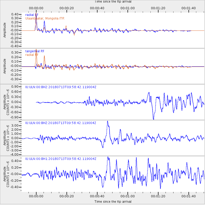
Signal To Noise
| Channel | StoN | STA | LTA |
| IU:ULN:00:BHZ:20180713T09:58:42.119004Z | 7.5451818 | 3.9406277E-7 | 5.2227072E-8 |
| IU:ULN:00:BH1:20180713T09:58:42.119004Z | 2.2471042 | 5.6302106E-8 | 2.5055405E-8 |
| IU:ULN:00:BH2:20180713T09:58:42.119004Z | 3.7873044 | 9.546629E-8 | 2.5206923E-8 |
| Arrivals |
| Ps | 5.4 SECOND |
| PpPs | 20 SECOND |
| PsPs/PpSs | 25 SECOND |


