You are here: Home > Network List > US - United States National Seismic Network Stations List
> Station MSO Missoula, Montana, USA > Earthquake Result Viewer
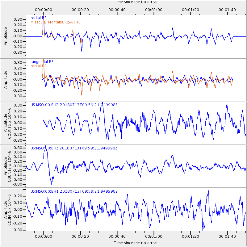
MSO Missoula, Montana, USA - Earthquake Result Viewer
*The percent match for this event was below the threshold and hence no stack was calculated.
| Earthquake location: |
Vanuatu Islands |
| Earthquake latitude/longitude: |
-18.9/169.0 |
| Earthquake time(UTC): |
2018/07/13 (194) 09:46:49 GMT |
| Earthquake Depth: |
169 km |
| Earthquake Magnitude: |
6.4 Mww |
| Earthquake Catalog/Contributor: |
NEIC PDE/us |
|
| Network: |
US United States National Seismic Network |
| Station: |
MSO Missoula, Montana, USA |
| Lat/Lon: |
46.83 N/113.94 W |
| Elevation: |
1264 m |
|
| Distance: |
95.1 deg |
| Az: |
42.203 deg |
| Baz: |
247.833 deg |
| Ray Param: |
$rayparam |
*The percent match for this event was below the threshold and hence was not used in the summary stack. |
|
| Radial Match: |
75.48685 % |
| Radial Bump: |
400 |
| Transverse Match: |
55.78191 % |
| Transverse Bump: |
400 |
| SOD ConfigId: |
2768671 |
| Insert Time: |
2018-07-27 09:50:57.308 +0000 |
| GWidth: |
2.5 |
| Max Bumps: |
400 |
| Tol: |
0.001 |
|
Signal To Noise
| Channel | StoN | STA | LTA |
| US:MSO:00:BHZ:20180713T09:59:21.949998Z | 5.8234158 | 5.6256914E-7 | 9.6604666E-8 |
| US:MSO:00:BH1:20180713T09:59:21.949998Z | 0.96358377 | 8.365795E-8 | 8.68196E-8 |
| US:MSO:00:BH2:20180713T09:59:21.949998Z | 2.253475 | 1.9796724E-7 | 8.784976E-8 |
| Arrivals |
| Ps | |
| PpPs | |
| PsPs/PpSs | |


