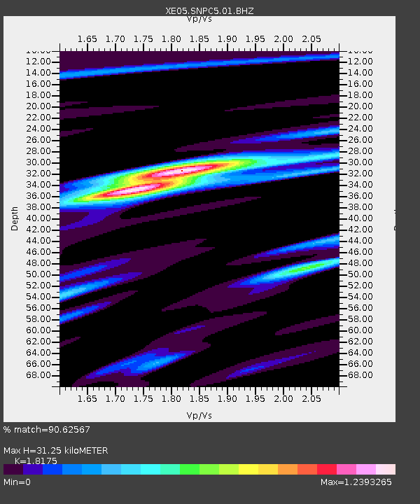
SNPC5 SNPC5 - Earthquake Result Viewer

Earthquake location: Kuril Islands
Earthquake latitude/longitude: 46.4/153.2
Earthquake time(UTC): 2006/09/30 (273) 17:50:23 GMT
Earthquake Depth: 11 km
Earthquake Magnitude: 6.1 MB, 6.5 MS, 6.6 MW, 6.6 MW
Earthquake Catalog/Contributor: WHDF/NEIC
Network: XE Sierra Nevada EarthScope Project- EarthScope Flex Array
Station: SNPC5 SNPC5
Lat/Lon: 39.03 N/120.75 W
Elevation: 1006 m
Distance: 60.7 deg
Az: 62.997 deg
Baz: 307.596 deg
Ray Param: 0.061349556
Estimated Moho Depth: 31.25 km
Estimated Crust Vp/Vs: 1.82
Assumed Crust Vp: 6.597 km/s
Estimated Crust Vs: 3.63 km/s
Estimated Crust Poisson's Ratio: 0.28
Radial Match: 90.62567 %
Radial Bump: 400
Transverse Match: 77.461975 %
Transverse Bump: 400
SOD ConfigId: 268666
Insert Time: 2010-03-09 18:22:00.795 +0000
GWidth: 2.5
Max Bumps: 400
Tol: 0.001

Signal To Noise

ChannelStoNSTALTA
XE:SNPC5:01:BHZ:20060930T18:00:03.289014Z7.32426836.1914426E-78.4533255E-8
XE:SNPC5:01:BHN:20060930T18:00:03.289014Z2.9388153.453573E-71.1751583E-7
XE:SNPC5:01:BHE:20060930T18:00:03.289014Z3.20550562.8472093E-78.882247E-8
Arrivals
Ps4.1 SECOND
PpPs13 SECOND
PsPs/PpSs17 SECOND